You are here: Home > Network List > XG92 - Rocky Mountain Front Stations List
> Station BTO outside Loveland, CO > Earthquake Result Viewer
BTO outside Loveland, CO - Earthquake Result Viewer
| Earthquake location: |
Near Coast Of Nicaragua |
| Earthquake latitude/longitude: |
11.3/-86.8 |
| Earthquake time(UTC): |
1992/09/02 (246) 18:28:56 GMT |
| Earthquake Depth: |
10 km |
| Earthquake Magnitude: |
5.2 MB, 5.8 MS |
| Earthquake Catalog/Contributor: |
WHDF/NEIC |
|
| Network: |
XG Rocky Mountain Front |
| Station: |
BTO outside Loveland, CO |
| Lat/Lon: |
40.39 N/105.20 W |
| Elevation: |
1609 m |
|
| Distance: |
33.3 deg |
| Az: |
333.853 deg |
| Baz: |
145.529 deg |
| Ray Param: |
0.07828782 |
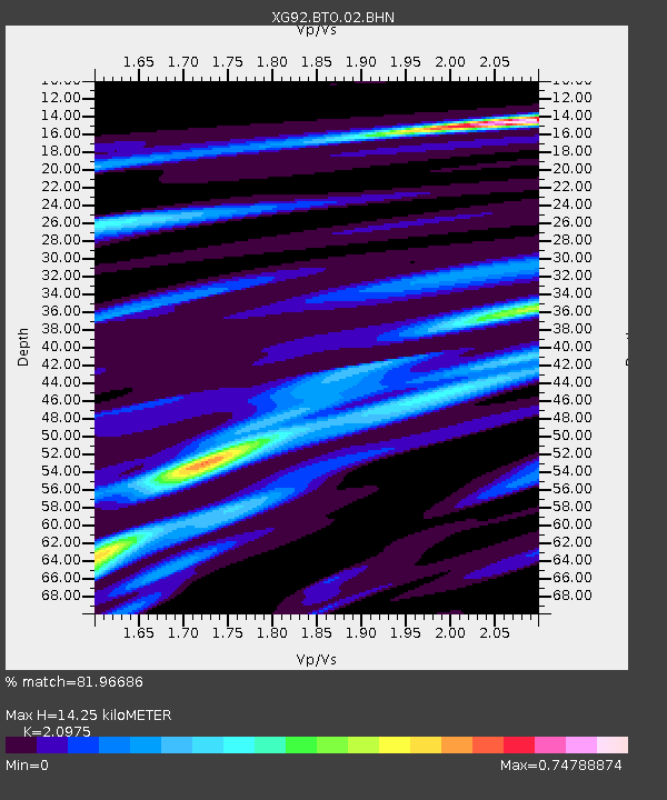
| Estimated Moho Depth: |
14.25 km |
| Estimated Crust Vp/Vs: |
2.10 |
| Assumed Crust Vp: |
6.306 km/s |
| Estimated Crust Vs: |
3.006 km/s |
| Estimated Crust Poisson's Ratio: |
0.35 |
|
| Radial Match: |
81.96686 % |
| Radial Bump: |
323 |
| Transverse Match: |
87.96517 % |
| Transverse Bump: |
264 |
| SOD ConfigId: |
3286 |
| Insert Time: |
2010-02-25 20:07:21.816 +0000 |
| GWidth: |
2.5 |
| Max Bumps: |
400 |
| Tol: |
0.001 |
|

Signal To Noise
| Channel | StoN | STA | LTA |
| XG:BTO:02:BHN:19920902T18:35:03.065009Z | 2.2942834 | 6.000859E-5 | 2.61557E-5 |
| XG:BTO:02:BHE:19920902T18:35:03.065009Z | 4.8768406 | 2.3744372E-4 | 4.868802E-5 |
| XG:BTO:02:BHZ:19920902T18:35:03.065009Z | 7.746953 | 4.384813E-4 | 5.6600482E-5 |
| Arrivals |
| Ps | 2.6 SECOND |
| PpPs | 6.6 SECOND |
| PsPs/PpSs | 9.2 SECOND |


