
Station XG BTO - outside Loveland, CO
Network: XG92 - Rocky Mountain Front
Nearby stations (2 deg radius)
| Station | Name | (Lat, Lon) | Start / End | Elevation |
| BTO | outside Loveland, CO | (40.39, -105.20) | 1992-05-23 / 2499-01-01 | 1.6 km |
| Crust2 Type: | P4,orogen/50km, Urals, Tethian Orogen, Rockies 1 km seds. |
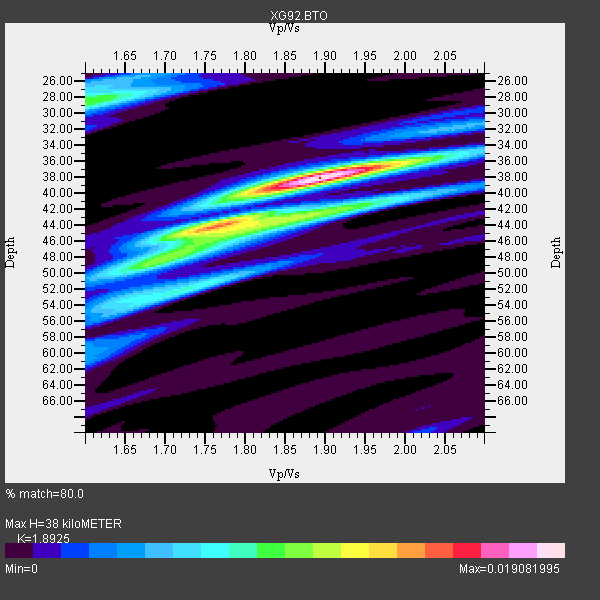
| Thickness Estimate: | 38 km |
| Thickness StdDev: | 3.8 km |
| Vp/Vs Estimate: | 1.89 |
| Vp/Vs StdDev: | 0.08 |
| Vs Estimate: | 3.332 km/s |
| Poisson's Ratio: | 0.31 |
| Peak Value: | 0.02 |
| Assumed Vp: | 6.306 km/s |
| Ps Weight: | 0.33333334 |
| PpPs Weight: | 0.33333334 |
| PsPs Weight: | 0.33333328 |
| Residual Complexity: | 0.655 |
| Nearby stations H: | +- |
| (2.0 deg) Vp/Vs: | +- |
12 with match > 90% ( 75.0 %) and 16 with match > 80% ( 100.0 %) out of 16.
Download stack as xyz text file.
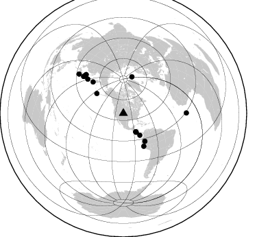
Azimuth Distribution of Events:
Prior Results for this Station
| Study | Thickness | Vp/Vs | Vp | Vs | Poissons Ratio | Extra |
| EARS | 38 km | 1.89 | 6.306 km/s | 3.332 km/s | 0.31 | |
| Crust2.0 | 50 km | 1.76 | 6.306 km/s | 3.584 km/s | 0.26 | P4,orogen/50km, Urals, Tethian Orogen, Rockies 1 km seds. |
| Global Maxima | 38 km | 1.89 | 6.306 km/s | 3.332 km/s | 0.31 | amp=0.019081995 |
| Local Maxima 1 | 44 km | 1.75 | 6.306 km/s | 3.593 km/s | 0.26 | amp=0.011571656 |
| Local Maxima 2 | 29 km | 1.60 | 6.306 km/s | 3.941 km/s | 0.18 | amp=0.00957935 |
| Local Maxima 3 | 52 km | 1.72 | 6.306 km/s | 3.666 km/s | 0.24 | amp=0.007752296 |
| Local Maxima 4 | 43 km | 1.89 | 6.306 km/s | 3.332 km/s | 0.31 | amp=0.0065851687 |
| Predicted Arrivals for vertical incidence (zero ray parameter) | |
| Ps | 5.38 SECOND |
| PpPs | 17.43 SECOND |
| PsPs/PpSs | 22.81 SECOND |
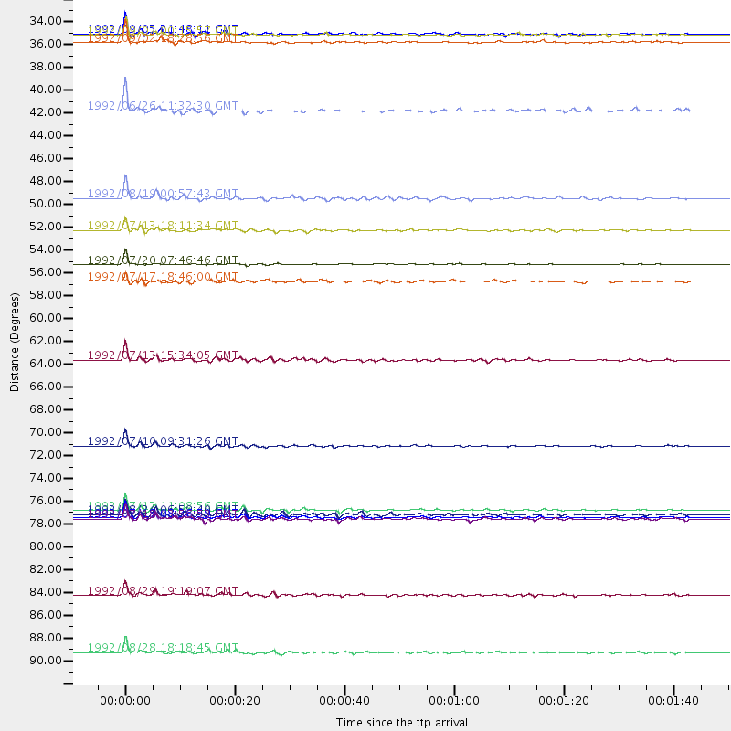
Events Processed for this Station
Download zip of receiver functions as SAC
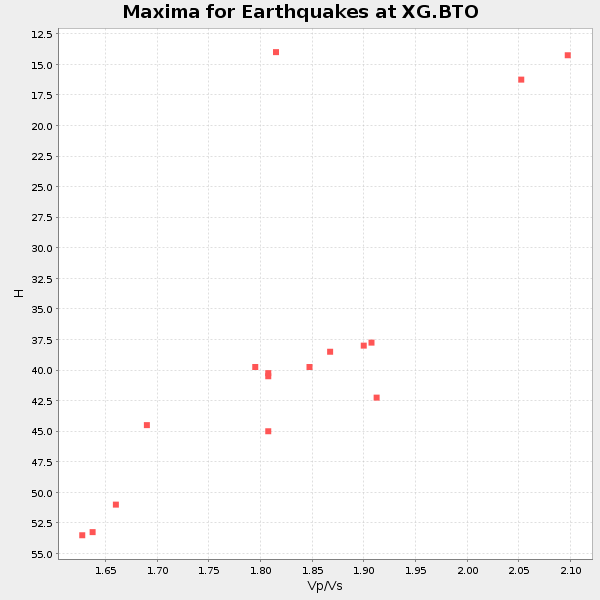
Plot maxima for each earthquake.
Events Used in the Stack
(16 events)| Radial Match | Distance | Baz | FERegion | Time | Lat/Lon | Depth | Magnitude |
| 99.116776 | 54.6 deg | 13.388 deg | Svalbard Region | 1992/07/20 07:46:46 GMT | (78.5, 5.1) | 10 km | 5.8 MB, 6.3 MS |
| 97.93276 | 78.3 deg | 314.915 deg | Hokkaido, Japan Region | 1992/07/12 11:08:56 GMT | (41.4, 142.1) | 70 km | 5.9 MB |
| 97.883 | 72.0 deg | 313.651 deg | Kuril Islands | 1992/07/10 09:31:26 GMT | (44.7, 149.5) | 11 km | 6.1 MB, 6.5 MS |
| 96.599785 | 79.0 deg | 312.669 deg | Off East Coast Of Honshu, Japan | 1992/07/18 08:36:59 GMT | (39.4, 143.4) | 33 km | 6.1 MB, 6.9 MS |
| 96.335014 | 63.8 deg | 315.856 deg | Near East Coast Of Kamchatka | 1992/07/13 15:34:05 GMT | (51.2, 157.7) | 53 km | 5.7 MB |
| 95.41274 | 32.5 deg | 146.232 deg | Near Coast Of Nicaragua | 1992/09/02 00:15:57 GMT | (11.8, -87.4) | 10 km | 5.3 MB, 7.2 MS |
| 94.88741 | 48.2 deg | 306.553 deg | Andreanof Islands, Aleutian Is. | 1992/08/19 00:57:43 GMT | (50.5, -174.8) | 33 km | 6.1 MB, 5.7 MS, 5.6 ML |
| 94.514114 | 78.6 deg | 315.987 deg | Hokkaido, Japan Region | 1992/08/24 06:59:40 GMT | (41.9, 140.7) | 127 km | 6.2 MB |
| 94.24067 | 51.3 deg | 142.305 deg | Northern Peru | 1992/07/13 18:11:34 GMT | (-3.9, -76.6) | 100 km | 6.2 MB |
| 93.92679 | 91.9 deg | 89.695 deg | North Of Ascension Island | 1992/08/28 18:18:45 GMT | (-1.0, -13.6) | 10 km | 6.4 MB, 7.0 MS |
| 93.24799 | 86.4 deg | 311.379 deg | Southeast Of Honshu, Japan | 1992/08/29 19:19:07 GMT | (33.2, 138.0) | 309 km | 6.0 MB |
| 90.8135 | 39.8 deg | 142.922 deg | South Of Panama | 1992/06/26 11:32:30 GMT | (6.1, -82.4) | 33 km | 5.8 MB, 5.4 MS |
| 88.75297 | 32.4 deg | 145.935 deg | Near Coast Of Nicaragua | 1992/09/05 21:48:11 GMT | (12.0, -87.3) | 10 km | 5.1 MB, 5.9 MS |
| 84.07922 | 79.1 deg | 312.937 deg | Off East Coast Of Honshu, Japan | 1992/07/18 13:56:53 GMT | (39.5, 143.0) | 21 km | 5.7 MB, 6.0 MS |
| 81.96686 | 33.3 deg | 145.529 deg | Near Coast Of Nicaragua | 1992/09/02 18:28:56 GMT | (11.3, -86.8) | 10 km | 5.2 MB, 5.8 MS |
| 80.243965 | 56.2 deg | 147.947 deg | Near Coast Of Peru | 1992/07/17 18:46:00 GMT | (-10.4, -78.6) | 44 km | 5.5 MB, 5.4 MS |
Losers
(0 events)| Radial Match | Distance | Baz | FERegion | Time | Lat/Lon | Depth | Magnitude | Reason |
