You are here: Home > Network List > XG92 - Rocky Mountain Front Stations List
> Station BTO outside Loveland, CO > Earthquake Result Viewer
BTO outside Loveland, CO - Earthquake Result Viewer

| Earthquake location: |
Southeast Of Honshu, Japan |
| Earthquake latitude/longitude: |
33.2/138.0 |
| Earthquake time(UTC): |
1992/08/29 (242) 19:19:07 GMT |
| Earthquake Depth: |
309 km |
| Earthquake Magnitude: |
6.0 MB |
| Earthquake Catalog/Contributor: |
WHDF/NEIC |
|
| Network: |
XG Rocky Mountain Front |
| Station: |
BTO outside Loveland, CO |
| Lat/Lon: |
40.39 N/105.20 W |
| Elevation: |
1609 m |
|
| Distance: |
86.4 deg |
| Az: |
43.093 deg |
| Baz: |
311.379 deg |
| Ray Param: |
0.04330426 |
| Estimated Moho Depth: |
39.75 km |
| Estimated Crust Vp/Vs: |
1.85 |
| Assumed Crust Vp: |
6.306 km/s |
| Estimated Crust Vs: |
3.413 km/s |
| Estimated Crust Poisson's Ratio: |
0.29 |
|
| Radial Match: |
93.24799 % |
| Radial Bump: |
360 |
| Transverse Match: |
88.02922 % |
| Transverse Bump: |
400 |
| SOD ConfigId: |
3286 |
| Insert Time: |
2010-02-25 20:07:25.798 +0000 |
| GWidth: |
2.5 |
| Max Bumps: |
400 |
| Tol: |
0.001 |
|
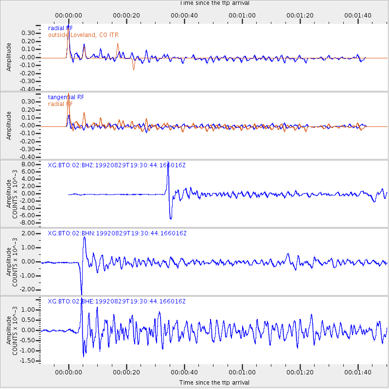
Signal To Noise
| Channel | StoN | STA | LTA |
| XG:BTO:02:BHN:19920829T19:30:44.166016Z | 30.642475 | 6.340565E-4 | 2.069208E-5 |
| XG:BTO:02:BHE:19920829T19:30:44.166016Z | 11.425618 | 4.3004553E-4 | 3.763871E-5 |
| XG:BTO:02:BHZ:19920829T19:30:44.166016Z | 44.589687 | 0.002413585 | 5.4128777E-5 |
| Arrivals |
| Ps | 5.5 SECOND |
| PpPs | 18 SECOND |
| PsPs/PpSs | 23 SECOND |


