You are here: Home > Network List > TA - USArray Transportable Network (new EarthScope stations) Stations List
> Station W37A Quinton, OK, USA > Earthquake Result Viewer
W37A Quinton, OK, USA - Earthquake Result Viewer

| Earthquake location: |
Ecuador |
| Earthquake latitude/longitude: |
-1.3/-77.3 |
| Earthquake time(UTC): |
2010/08/12 (224) 11:54:15 GMT |
| Earthquake Depth: |
207 km |
| Earthquake Magnitude: |
6.4 MB, 7.1 MW, 7.1 MW |
| Earthquake Catalog/Contributor: |
WHDF/NEIC |
|
| Network: |
TA USArray Transportable Network (new EarthScope stations) |
| Station: |
W37A Quinton, OK, USA |
| Lat/Lon: |
35.14 N/95.43 W |
| Elevation: |
281 m |
|
| Distance: |
40.0 deg |
| Az: |
336.63 deg |
| Baz: |
151.062 deg |
| Ray Param: |
0.07386586 |
| Estimated Moho Depth: |
47.75 km |
| Estimated Crust Vp/Vs: |
1.61 |
| Assumed Crust Vp: |
6.498 km/s |
| Estimated Crust Vs: |
4.036 km/s |
| Estimated Crust Poisson's Ratio: |
0.19 |
|
| Radial Match: |
97.63589 % |
| Radial Bump: |
302 |
| Transverse Match: |
90.34482 % |
| Transverse Bump: |
400 |
| SOD ConfigId: |
319893 |
| Insert Time: |
2011-01-05 20:55:02.131 +0000 |
| GWidth: |
2.5 |
| Max Bumps: |
400 |
| Tol: |
0.001 |
|
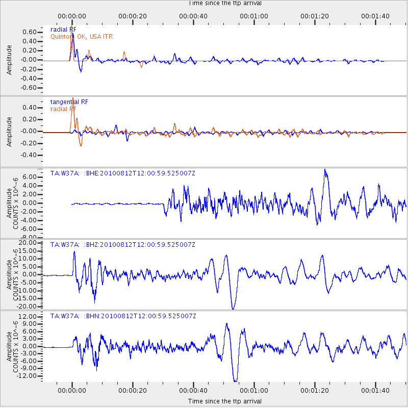
Signal To Noise
| Channel | StoN | STA | LTA |
| TA:W37A: :BHZ:20100812T12:00:59.525007Z | 77.67568 | 6.18927E-6 | 7.968092E-8 |
| TA:W37A: :BHN:20100812T12:00:59.525007Z | 40.815105 | 2.7080273E-6 | 6.6348655E-8 |
| TA:W37A: :BHE:20100812T12:00:59.525007Z | 18.157942 | 1.4503726E-6 | 7.9875385E-8 |
| Arrivals |
| Ps | 4.8 SECOND |
| PpPs | 18 SECOND |
| PsPs/PpSs | 23 SECOND |


