You are here: Home > Network List > YX10 - Flexarray 3D Passive Seismic Imaging of Core-Complex Extension in the Ruby Range Nevada Stations List
> Station A07 Long Canyon > Earthquake Result Viewer
A07 Long Canyon - Earthquake Result Viewer
| Earthquake location: |
Ecuador |
| Earthquake latitude/longitude: |
-1.3/-77.3 |
| Earthquake time(UTC): |
2010/08/12 (224) 11:54:15 GMT |
| Earthquake Depth: |
207 km |
| Earthquake Magnitude: |
6.4 MB, 7.1 MW, 7.1 MW |
| Earthquake Catalog/Contributor: |
WHDF/NEIC |
|
| Network: |
YX Flexarray 3D Passive Seismic Imaging of Core-Complex Extension in the Ruby Range Nevada |
| Station: |
A07 Long Canyon |
| Lat/Lon: |
40.56 N/115.53 W |
| Elevation: |
1917 m |
|
| Distance: |
54.3 deg |
| Az: |
324.493 deg |
| Baz: |
130.348 deg |
| Ray Param: |
0.06484927 |
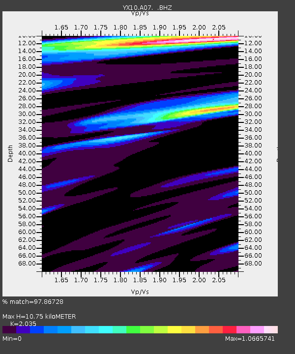
| Estimated Moho Depth: |
10.75 km |
| Estimated Crust Vp/Vs: |
2.04 |
| Assumed Crust Vp: |
6.276 km/s |
| Estimated Crust Vs: |
3.084 km/s |
| Estimated Crust Poisson's Ratio: |
0.34 |
|
| Radial Match: |
97.86728 % |
| Radial Bump: |
400 |
| Transverse Match: |
95.85044 % |
| Transverse Bump: |
400 |
| SOD ConfigId: |
319893 |
| Insert Time: |
2011-01-05 21:08:00.799 +0000 |
| GWidth: |
2.5 |
| Max Bumps: |
400 |
| Tol: |
0.001 |
|

Signal To Noise
| Channel | StoN | STA | LTA |
| YX:A07: :BHZ:20100812T12:02:49.355024Z | 62.241447 | 3.6737397E-6 | 5.9024007E-8 |
| YX:A07: :BHN:20100812T12:02:49.355024Z | 14.888425 | 1.1145158E-6 | 7.485787E-8 |
| YX:A07: :BHE:20100812T12:02:49.355024Z | 50.901253 | 1.3843991E-6 | 2.7197741E-8 |
| Arrivals |
| Ps | 1.9 SECOND |
| PpPs | 5.0 SECOND |
| PsPs/PpSs | 6.8 SECOND |


