
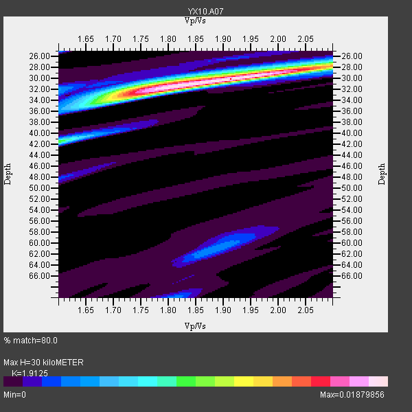
Station YX A07 - Long Canyon
Network: YX10 - Flexarray 3D Passive Seismic Imaging of Core-Complex Extension in the Ruby Range Nevada
Nearby stations (2 deg radius)
| Station | Name | (Lat, Lon) | Start / End | Elevation |
| A07 | Long Canyon | (40.56, -115.53) | 2010-06-15 / 2011-12-31 | 1917 m |
| Crust2 Type: | M5,extended crust, 0.5 km seds. |
| Thickness Estimate: | 30 km |
| Thickness StdDev: | 1.0 km |
| Vp/Vs Estimate: | 1.91 |
| Vp/Vs StdDev: | 0.10 |
| Vs Estimate: | 3.281 km/s |
| Poisson's Ratio: | 0.31 |
| Peak Value: | 0.02 |
| Assumed Vp: | 6.276 km/s |
| Ps Weight: | 0.33333334 |
| PpPs Weight: | 0.33333334 |
| PsPs Weight: | 0.33333328 |
| Residual Complexity: | 0.490 |
| Nearby stations H: | +- |
| (2.0 deg) Vp/Vs: | +- |
5 with match > 90% ( 16.129032 %) and 8 with match > 80% ( 25.806452 %) out of 31.
Download stack as xyz text file.
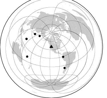
Azimuth Distribution of Events:
Prior Results for this Station
| Study | Thickness | Vp/Vs | Vp | Vs | Poissons Ratio | Extra |
| EARS | 30 km | 1.91 | 6.276 km/s | 3.281 km/s | 0.31 | |
| Crust2.0 | 31 km | 1.78 | 6.276 km/s | 3.529 km/s | 0.27 | M5,extended crust, 0.5 km seds. |
| Global Maxima | 30 km | 1.91 | 6.276 km/s | 3.281 km/s | 0.31 | amp=0.01879856 |
| Local Maxima 1 | 33 km | 1.74 | 6.276 km/s | 3.617 km/s | 0.25 | amp=0.011169147 |
| Local Maxima 2 | 41 km | 1.60 | 6.276 km/s | 3.922 km/s | 0.18 | amp=0.008486452 |
| Local Maxima 3 | 28 km | 2.10 | 6.276 km/s | 2.992 km/s | 0.35 | amp=0.008007038 |
| Local Maxima 4 | 31 km | 1.77 | 6.276 km/s | 3.541 km/s | 0.27 | amp=0.003787797 |
| Predicted Arrivals for vertical incidence (zero ray parameter) | |
| Ps | 4.36 SECOND |
| PpPs | 13.92 SECOND |
| PsPs/PpSs | 18.28 SECOND |
Events Processed for this Station
Download zip of receiver functions as SAC
Plot maxima for each earthquake.
Events Used in the Stack
(8 events)| Radial Match | Distance | Baz | FERegion | Time | Lat/Lon | Depth | Magnitude |
| 98.46039 | 91.3 deg | 248.063 deg | Vanuatu Islands | 2010/08/10 05:23:44 GMT | (-17.5, 168.1) | 25 km | 6.4 MB, 7.3 MS, 7.3 MW, 7.2 MW |
| 97.86728 | 54.3 deg | 130.348 deg | Ecuador | 2010/08/12 11:54:15 GMT | (-1.3, -77.3) | 207 km | 6.4 MB, 7.1 MW, 7.1 MW |
| 95.18016 | 91.6 deg | 287.821 deg | South Of Mariana Islands | 2010/08/13 21:19:33 GMT | (12.5, 141.5) | 10 km | 6.5 MB, 6.9 MS, 6.9 MW, 6.9 MW |
| 94.04357 | 56.2 deg | 312.913 deg | Off East Coast Of Kamchatka | 2010/07/30 03:56:13 GMT | (52.5, 159.8) | 23 km | 6.1 MB, 6.3 MS, 6.3 MW, 6.3 MW |
| 92.93624 | 91.7 deg | 287.713 deg | South Of Mariana Islands | 2010/08/14 07:30:16 GMT | (12.3, 141.5) | 10 km | 6.0 MB, 6.0 MS, 6.2 MW, 6.1 MW |
| 86.93579 | 73.2 deg | 308.005 deg | Near East Coast Of Honshu, Japan | 2010/07/04 21:55:51 GMT | (39.7, 142.4) | 27 km | 6.4 MB, 6.1 MS, 6.3 MW, 6.2 MW |
| 86.83312 | 91.6 deg | 287.664 deg | South Of Mariana Islands | 2010/08/14 07:31:01 GMT | (12.4, 141.6) | 10 km | 5.7 MB |
| 84.773 | 87.3 deg | 147.93 deg | Near Coast Of Central Chile | 2010/07/14 08:32:21 GMT | (-38.1, -73.3) | 22 km | 5.9 MB, 6.5 MS, 6.6 MW, 6.5 MW |
Losers
(23 events)| Radial Match | Distance | Baz | FERegion | Time | Lat/Lon | Depth | Magnitude | Reason |
| 88.655685 | 38.3 deg | 307.444 deg | Fox Islands, Aleutian Islands | 2010/07/18 05:56:44 GMT | (52.9, -169.8) | 14 km | 6.3 MB, 6.7 MS, 6.6 MW, 6.6 MW | |
| 85.20715 | 89.9 deg | 251.964 deg | Vanuatu Islands | 2010/07/02 06:04:03 GMT | (-13.6, 166.5) | 29 km | 5.8 MB, 6.2 MS, 6.3 MW, 6.3 MW | |
| 77.14928 | 96.9 deg | 268.083 deg | New Britain Region, P.N.G. | 2010/07/18 13:04:09 GMT | (-6.0, 150.4) | 28 km | 6.3 MB, 7.1 MS, 6.9 MW, 6.8 MW | |
| 75.60008 | 89.2 deg | 283.886 deg | South Of Mariana Islands | 2010/07/10 11:43:32 GMT | (11.1, 146.0) | 13 km | 6.2 MB, 6.1 MS, 6.3 MW, 6.3 MW | |
| 72.99708 | 91.6 deg | 257.468 deg | Solomon Islands | 2010/06/26 05:30:19 GMT | (-10.6, 161.4) | 35 km | 6.4 MB, 6.8 MS, 6.7 MW, 6.6 MW | |
| 72.89967 | 89.7 deg | 249.76 deg | Vanuatu Islands | 2010/07/22 05:03:57 GMT | (-15.1, 168.2) | 10 km | 6.2 MB, 5.4 MS, 6.1 MW, 5.9 MW | |
| 68.29565 | 72.9 deg | 307.374 deg | Off East Coast Of Honshu, Japan | 2010/08/10 05:50:37 GMT | (39.4, 143.1) | 22 km | 5.8 MB | |
| 65.4007 | 87.9 deg | 236.742 deg | South Of Fiji Islands | 2010/06/30 04:31:02 GMT | (-23.3, 179.1) | 581 km | 5.8 MB, 6.4 MW, 6.3 MW | |
| 60.91838 | 96.7 deg | 267.872 deg | New Britain Region, P.N.G. | 2010/07/20 20:31:08 GMT | (-6.0, 150.7) | 35 km | 5.5 MS, 5.3 MB, 5.6 MW | |
| 57.65702 | 96.1 deg | 267.956 deg | New Britain Region, P.N.G. | 2010/06/24 05:32:27 GMT | (-5.5, 151.2) | 40 km | 5.8 MB, 5.8 MS, 6.1 MW, 6.1 MW | |
| 54.770576 | 91.8 deg | 287.611 deg | South Of Mariana Islands | 2010/08/18 16:28:15 GMT | (12.2, 141.5) | 10 km | 5.8 MB, 5.9 MS, 6.3 MW, 6.2 MW | |
| 51.53638 | 88.2 deg | 231.876 deg | South Of Fiji Islands | 2010/08/04 04:46:20 GMT | (-26.9, -177.2) | 18 km | 5.7 MB, 5.8 MS, 6.0 MW, 5.9 MW | |
| 50.861485 | 88.0 deg | 286.655 deg | Mariana Islands | 2010/07/10 05:39:43 GMT | (14.0, 145.0) | 136 km | 5.6 MB, 5.6 MW, 5.5 MW | |
| 46.49923 | 94.0 deg | 265.356 deg | Solomon Islands | 2010/07/07 06:50:40 GMT | (-6.2, 154.4) | 35 km | 5.6 MS, 5.3 MB, 5.9 MW, 5.7 MW | |
| 44.730957 | 76.3 deg | 135.469 deg | Northern Chile | 2010/07/12 00:11:21 GMT | (-22.1, -68.2) | 115 km | 6.1 MB, 6.3 MW, 6.2 MW | |
| 43.87651 | 79.5 deg | 301.323 deg | Southeast Of Honshu, Japan | 2010/06/28 12:07:25 GMT | (30.7, 141.6) | 7.0 km | 5.5 MS, 5.4 MB, 5.8 MW, 5.7 MW | |
| 43.65788 | 77.1 deg | 237.194 deg | Tonga Islands | 2010/07/25 03:39:17 GMT | (-15.1, -173.5) | 7.0 km | 5.6 MB, 5.7 MS, 5.9 MW, 5.9 MW | |
| 33.61612 | 96.7 deg | 267.946 deg | New Britain Region, P.N.G. | 2010/07/20 19:18:21 GMT | (-5.9, 150.7) | 35 km | 5.6 MB, 6.3 MS, 6.3 MW, 6.3 MW | |
| 30.940184 | 89.8 deg | 250.802 deg | Vanuatu Islands | 2010/08/10 23:18:31 GMT | (-14.5, 167.3) | 192 km | 5.9 MW, 5.4 MB, 5.9 MW | |
| 26.27537 | 84.7 deg | 237.075 deg | Fiji Islands Region | 2010/08/16 19:35:49 GMT | (-20.8, -178.8) | 603 km | 5.7 MB, 6.2 MW, 6.1 MW | |
| 26.233858 | 60.4 deg | 311.69 deg | Kuril Islands | 2010/07/25 12:57:01 GMT | (49.7, 154.6) | 130 km | 5.7 MB, 5.6 MW, 5.6 MW | |
| 25.227991 | 87.4 deg | 147.956 deg | Near Coast Of Central Chile | 2010/07/14 15:05:50 GMT | (-38.2, -73.2) | 35 km | 5.5 MS, 5.4 MB, 5.8 MW, 5.7 MW | |
| 22.160095 | 91.4 deg | 248.328 deg | Vanuatu Islands | 2010/08/11 03:35:19 GMT | (-17.4, 167.8) | 35 km | 5.6 MB, 5.7 MS, 5.8 MW |
