You are here: Home > Network List > XU06 - Cascadia Arrays For Earthscope Stations List
> Station W030 Quilcene, WA, USA > Earthquake Result Viewer
W030 Quilcene, WA, USA - Earthquake Result Viewer
| Earthquake location: |
South Of Mariana Islands |
| Earthquake latitude/longitude: |
12.5/141.5 |
| Earthquake time(UTC): |
2010/08/13 (225) 21:19:33 GMT |
| Earthquake Depth: |
10 km |
| Earthquake Magnitude: |
6.5 MB, 6.9 MS, 6.9 MW, 6.9 MW |
| Earthquake Catalog/Contributor: |
WHDF/NEIC |
|
| Network: |
XU Cascadia Arrays For Earthscope |
| Station: |
W030 Quilcene, WA, USA |
| Lat/Lon: |
47.81 N/122.91 W |
| Elevation: |
69 m |
|
| Distance: |
84.6 deg |
| Az: |
42.361 deg |
| Baz: |
282.492 deg |
| Ray Param: |
0.04537362 |
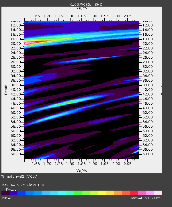
| Estimated Moho Depth: |
19.75 km |
| Estimated Crust Vp/Vs: |
1.60 |
| Assumed Crust Vp: |
6.566 km/s |
| Estimated Crust Vs: |
4.104 km/s |
| Estimated Crust Poisson's Ratio: |
0.18 |
|
| Radial Match: |
82.77057 % |
| Radial Bump: |
400 |
| Transverse Match: |
80.991875 % |
| Transverse Bump: |
400 |
| SOD ConfigId: |
319893 |
| Insert Time: |
2011-01-05 21:36:42.722 +0000 |
| GWidth: |
2.5 |
| Max Bumps: |
400 |
| Tol: |
0.001 |
|

Signal To Noise
| Channel | StoN | STA | LTA |
| XU:W030: :BHZ:20100813T21:31:35.019993Z | 9.777594 | 1.1333859E-6 | 1.15916656E-7 |
| XU:W030: :BHN:20100813T21:31:35.019993Z | 2.1366115 | 5.401106E-7 | 2.5278842E-7 |
| XU:W030: :BHE:20100813T21:31:35.019993Z | 2.0064776 | 3.7443144E-7 | 1.8661133E-7 |
| Arrivals |
| Ps | 1.9 SECOND |
| PpPs | 7.6 SECOND |
| PsPs/PpSs | 9.5 SECOND |


