You are here: Home > Network List > XG92 - Rocky Mountain Front Stations List
> Station BTO outside Loveland, CO > Earthquake Result Viewer
BTO outside Loveland, CO - Earthquake Result Viewer
| Earthquake location: |
Andreanof Islands, Aleutian Is. |
| Earthquake latitude/longitude: |
50.5/-174.8 |
| Earthquake time(UTC): |
1992/08/19 (232) 00:57:43 GMT |
| Earthquake Depth: |
33 km |
| Earthquake Magnitude: |
6.1 MB, 5.7 MS, 5.6 ML |
| Earthquake Catalog/Contributor: |
WHDF/NEIC |
|
| Network: |
XG Rocky Mountain Front |
| Station: |
BTO outside Loveland, CO |
| Lat/Lon: |
40.39 N/105.20 W |
| Elevation: |
1609 m |
|
| Distance: |
48.2 deg |
| Az: |
73.799 deg |
| Baz: |
306.553 deg |
| Ray Param: |
0.069438726 |
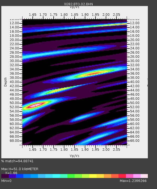
| Estimated Moho Depth: |
51.0 km |
| Estimated Crust Vp/Vs: |
1.66 |
| Assumed Crust Vp: |
6.306 km/s |
| Estimated Crust Vs: |
3.799 km/s |
| Estimated Crust Poisson's Ratio: |
0.22 |
|
| Radial Match: |
94.88741 % |
| Radial Bump: |
327 |
| Transverse Match: |
84.10621 % |
| Transverse Bump: |
400 |
| SOD ConfigId: |
3286 |
| Insert Time: |
2010-02-25 20:07:35.152 +0000 |
| GWidth: |
2.5 |
| Max Bumps: |
400 |
| Tol: |
0.001 |
|

Signal To Noise
| Channel | StoN | STA | LTA |
| XG:BTO:02:BHN:19920819T01:05:50.472009Z | 6.3013377 | 2.0688928E-4 | 3.28326E-5 |
| XG:BTO:02:BHE:19920819T01:05:50.472009Z | 7.722576 | 2.4182614E-4 | 3.131418E-5 |
| XG:BTO:02:BHZ:19920819T01:05:50.472009Z | 13.503394 | 6.123105E-4 | 4.5344932E-5 |
| Arrivals |
| Ps | 5.7 SECOND |
| PpPs | 20 SECOND |
| PsPs/PpSs | 26 SECOND |


