You are here: Home > Network List > XU06 - Cascadia Arrays For Earthscope Stations List
> Station PL11 Hoodsport, WA, USA > Earthquake Result Viewer
PL11 Hoodsport, WA, USA - Earthquake Result Viewer
| Earthquake location: |
South Of Mariana Islands |
| Earthquake latitude/longitude: |
12.4/141.6 |
| Earthquake time(UTC): |
2010/08/14 (226) 07:31:01 GMT |
| Earthquake Depth: |
10 km |
| Earthquake Magnitude: |
5.7 MB |
| Earthquake Catalog/Contributor: |
WHDF/NEIC |
|
| Network: |
XU Cascadia Arrays For Earthscope |
| Station: |
PL11 Hoodsport, WA, USA |
| Lat/Lon: |
47.45 N/123.15 W |
| Elevation: |
374 m |
|
| Distance: |
84.5 deg |
| Az: |
42.766 deg |
| Baz: |
282.187 deg |
| Ray Param: |
0.045471165 |
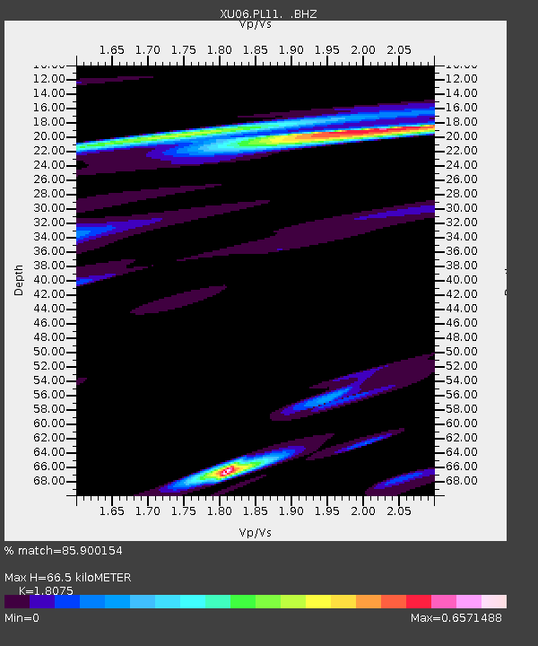
| Estimated Moho Depth: |
66.5 km |
| Estimated Crust Vp/Vs: |
1.81 |
| Assumed Crust Vp: |
6.566 km/s |
| Estimated Crust Vs: |
3.633 km/s |
| Estimated Crust Poisson's Ratio: |
0.28 |
|
| Radial Match: |
85.900154 % |
| Radial Bump: |
400 |
| Transverse Match: |
75.25444 % |
| Transverse Bump: |
400 |
| SOD ConfigId: |
319893 |
| Insert Time: |
2011-01-05 22:29:10.684 +0000 |
| GWidth: |
2.5 |
| Max Bumps: |
400 |
| Tol: |
0.001 |
|

Signal To Noise
| Channel | StoN | STA | LTA |
| XU:PL11: :BHZ:20100814T07:43:03.15999Z | 1.079922 | 7.187112E-7 | 6.655214E-7 |
| XU:PL11: :BHN:20100814T07:43:03.15999Z | 1.948994 | 5.225736E-7 | 2.6812478E-7 |
| XU:PL11: :BHE:20100814T07:43:03.15999Z | 1.1404561 | 4.238202E-7 | 3.7162346E-7 |
| Arrivals |
| Ps | 8.4 SECOND |
| PpPs | 28 SECOND |
| PsPs/PpSs | 36 SECOND |


