
Station XU PL11 - Hoodsport, WA, USA
Network: XU06 - Cascadia Arrays For Earthscope
Nearby stations (2 deg radius)
| Station | Name | (Lat, Lon) | Start / End | Elevation |
| PL11 | Hoodsport, WA, USA | (47.45, -123.15) | 2006-07-22 / 2009-12-31 | 374 m |
| Crust2 Type: | L8,thin continental arc, Cordilleras, 0.5 km seds. |
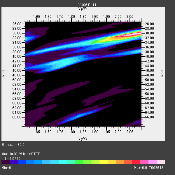
| Thickness Estimate: | 30 km |
| Thickness StdDev: | 8.0 km |
| Vp/Vs Estimate: | 2.07 |
| Vp/Vs StdDev: | 0.17 |
| Vs Estimate: | 3.168 km/s |
| Poisson's Ratio: | 0.35 |
| Peak Value: | 0.02 |
| Assumed Vp: | 6.566 km/s |
| Ps Weight: | 0.33333334 |
| PpPs Weight: | 0.33333334 |
| PsPs Weight: | 0.33333328 |
| Residual Complexity: | 0.553 |
| Nearby stations H: | +- |
| (2.0 deg) Vp/Vs: | +- |
4 with match > 90% ( 16.0 %) and 11 with match > 80% ( 44.0 %) out of 25.
Download stack as xyz text file.
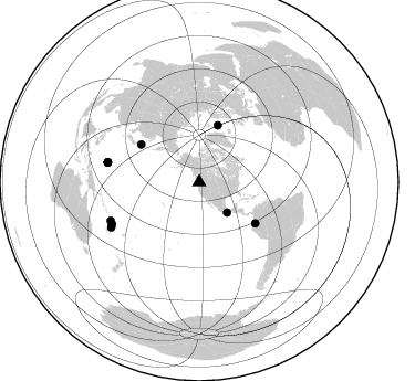
Azimuth Distribution of Events:
Prior Results for this Station
| Study | Thickness | Vp/Vs | Vp | Vs | Poissons Ratio | Extra |
| EARS | 30 km | 2.07 | 6.566 km/s | 3.168 km/s | 0.35 | |
| Crust2.0 | 34 km | 1.77 | 6.566 km/s | 3.707 km/s | 0.27 | L8,thin continental arc, Cordilleras, 0.5 km seds. |
| Global Maxima | 30 km | 2.07 | 6.566 km/s | 3.168 km/s | 0.35 | amp=0.017052948 |
| Local Maxima 1 | 33 km | 1.94 | 6.566 km/s | 3.389 km/s | 0.32 | amp=0.0077943164 |
| Local Maxima 2 | 38 km | 2.10 | 6.566 km/s | 3.13 km/s | 0.35 | amp=0.0062143556 |
| Local Maxima 3 | 32 km | 1.60 | 6.566 km/s | 4.104 km/s | 0.18 | amp=0.005870783 |
| Local Maxima 4 | 43 km | 1.77 | 6.566 km/s | 3.704 km/s | 0.27 | amp=0.005433555 |
| Predicted Arrivals for vertical incidence (zero ray parameter) | |
| Ps | 4.94 SECOND |
| PpPs | 14.15 SECOND |
| PsPs/PpSs | 19.10 SECOND |
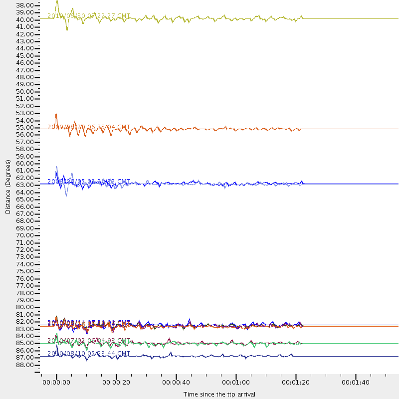
Events Processed for this Station
Download zip of receiver functions as SAC
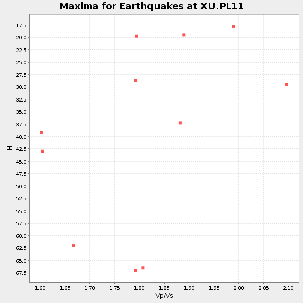
Plot maxima for each earthquake.
Events Used in the Stack
(11 events)| Radial Match | Distance | Baz | FERegion | Time | Lat/Lon | Depth | Magnitude |
| 96.08437 | 89.2 deg | 242.806 deg | Vanuatu Islands | 2010/08/10 05:23:44 GMT | (-17.5, 168.1) | 25 km | 6.4 MB, 7.3 MS, 7.3 MW, 7.2 MW |
| 94.32874 | 62.8 deg | 126.272 deg | Ecuador | 2010/08/12 11:54:15 GMT | (-1.3, -77.3) | 207 km | 6.4 MB, 7.1 MW, 7.1 MW |
| 93.13207 | 54.4 deg | 18.249 deg | Norwegian Sea | 2009/08/20 06:35:04 GMT | (72.2, 0.9) | 6.0 km | 5.9 MB, 5.7 MS, 6.0 MW, 6.0 MW |
| 91.64906 | 84.5 deg | 282.35 deg | South Of Mariana Islands | 2010/08/13 21:19:33 GMT | (12.5, 141.5) | 10 km | 6.5 MB, 6.9 MS, 6.9 MW, 6.9 MW |
| 85.900154 | 84.5 deg | 282.187 deg | South Of Mariana Islands | 2010/08/14 07:31:01 GMT | (12.4, 141.6) | 10 km | 5.7 MB |
| 85.639885 | 84.6 deg | 282.25 deg | South Of Mariana Islands | 2010/08/14 07:30:16 GMT | (12.3, 141.5) | 10 km | 6.0 MB, 6.0 MS, 6.2 MW, 6.1 MW |
| 84.81436 | 37.4 deg | 137.357 deg | Oaxaca, Mexico | 2010/06/30 07:22:27 GMT | (16.4, -97.8) | 20 km | 5.9 MB, 6.0 MS, 6.2 MW, 6.3 MW |
| 83.9592 | 87.2 deg | 246.451 deg | Vanuatu Islands | 2010/07/02 06:04:03 GMT | (-13.6, 166.5) | 29 km | 5.8 MB, 6.2 MS, 6.3 MW, 6.3 MW |
| 83.6239 | 84.7 deg | 282.153 deg | South Of Mariana Islands | 2010/08/18 16:28:15 GMT | (12.2, 141.5) | 10 km | 5.8 MB, 5.9 MS, 6.3 MW, 6.2 MW |
| 82.30094 | 62.8 deg | 302.941 deg | Hokkaido, Japan Region | 2009/06/05 03:30:33 GMT | (41.8, 143.4) | 29 km | 6.0 MB, 6.3 MS, 6.4 MW, 6.4 MW |
| 81.670006 | 87.3 deg | 244.238 deg | Vanuatu Islands | 2010/07/22 05:03:57 GMT | (-15.1, 168.2) | 10 km | 6.2 MB, 5.4 MS, 6.1 MW, 5.9 MW |
Losers
(14 events)| Radial Match | Distance | Baz | FERegion | Time | Lat/Lon | Depth | Magnitude | Reason |
| 78.32501 | 35.4 deg | 298.775 deg | Andreanof Islands, Aleutian Is. | 2008/03/22 21:24:11 GMT | (52.2, -178.7) | 132 km | 5.8 MB, 6.2 MW, 6.1 MW | |
| 76.99609 | 89.4 deg | 242.759 deg | Vanuatu Islands | 2009/06/02 02:17:03 GMT | (-17.8, 167.9) | 15 km | 5.7 MB, 6.2 MS, 6.3 MW, 6.3 MW | |
| 76.46941 | 76.8 deg | 229.859 deg | Tonga Islands | 2010/07/25 03:39:17 GMT | (-15.1, -173.5) | 7.0 km | 5.6 MB, 5.7 MS, 5.9 MW, 5.9 MW | |
| 76.29502 | 68.5 deg | 299.224 deg | Near East Coast Of Honshu, Japan | 2009/06/06 05:52:43 GMT | (35.5, 140.9) | 34 km | 5.8 MB, 5.4 MS, 5.8 MW, 5.7 MW | |
| 75.81948 | 54.4 deg | 302.248 deg | Kuril Islands | 2008/03/03 09:31:02 GMT | (46.4, 153.2) | 10 km | 6.2 MB, 6.5 MS, 6.5 MW, 6.5 MW | |
| 72.25233 | 43.5 deg | 124.143 deg | Honduras | 2009/06/08 05:13:14 GMT | (15.8, -86.9) | 10 km | 5.5 MB, 4.9 MS, 5.4 MW, 5.4 MW | |
| 70.003845 | 94.0 deg | 266.315 deg | Eastern New Guinea Reg., P.N.G. | 2010/08/04 07:15:34 GMT | (-5.5, 146.8) | 226 km | 6.1 MB, 6.5 MW, 6.4 MW | |
| 69.1004 | 87.5 deg | 231.088 deg | South Of Fiji Islands | 2010/06/30 04:31:02 GMT | (-23.3, 179.1) | 581 km | 5.8 MB, 6.4 MW, 6.3 MW | |
| 66.80694 | 90.7 deg | 240.571 deg | Loyalty Islands | 2008/04/09 11:13:17 GMT | (-20.2, 168.9) | 13 km | 5.6 MB, 6.3 MS, 6.4 MW, 6.3 MW | |
| 60.8954 | 89.4 deg | 242.952 deg | Vanuatu Islands | 2009/06/12 09:44:15 GMT | (-17.6, 167.8) | 15 km | 5.5 MB, 5.6 MS, 6.0 MW, 6.0 MW | |
| 59.873043 | 88.4 deg | 227.663 deg | South Of Fiji Islands | 2009/08/18 21:20:47 GMT | (-26.1, -178.4) | 270 km | 5.5 MB, 6.3 MW, 6.3 MW | |
| 58.867184 | 60.3 deg | 119.358 deg | Colombia | 2008/05/24 19:20:42 GMT | (4.3, -73.8) | 8.9 km | 5.6 MB, 5.6 MS, 5.9 MW, 5.9 MW | |
| 46.893417 | 83.2 deg | 231.026 deg | Fiji Islands Region | 2009/08/15 23:30:19 GMT | (-19.8, -178.2) | 608 km | 5.6 MW, 5.2 MB | |
| 40.060898 | 82.3 deg | 230.835 deg | Fiji Islands Region | 2010/06/22 22:16:20 GMT | (-19.2, -177.6) | 562 km | 5.8 MW, 5.1 MB, 5.8 MW |
