You are here: Home > Network List > YX10 - Flexarray 3D Passive Seismic Imaging of Core-Complex Extension in the Ruby Range Nevada Stations List
> Station A07 Long Canyon > Earthquake Result Viewer
A07 Long Canyon - Earthquake Result Viewer
| Earthquake location: |
South Of Mariana Islands |
| Earthquake latitude/longitude: |
12.4/141.6 |
| Earthquake time(UTC): |
2010/08/14 (226) 07:31:01 GMT |
| Earthquake Depth: |
10 km |
| Earthquake Magnitude: |
5.7 MB |
| Earthquake Catalog/Contributor: |
WHDF/NEIC |
|
| Network: |
YX Flexarray 3D Passive Seismic Imaging of Core-Complex Extension in the Ruby Range Nevada |
| Station: |
A07 Long Canyon |
| Lat/Lon: |
40.56 N/115.53 W |
| Elevation: |
1917 m |
|
| Distance: |
91.6 deg |
| Az: |
47.998 deg |
| Baz: |
287.664 deg |
| Ray Param: |
0.041592486 |
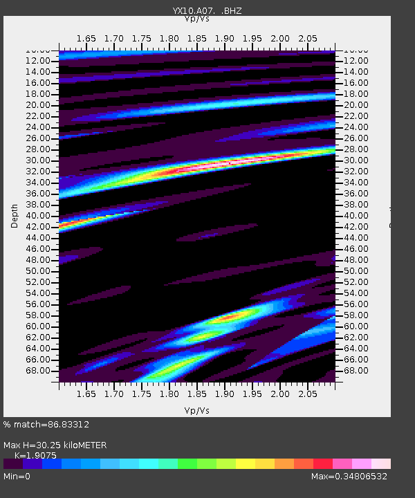
| Estimated Moho Depth: |
30.25 km |
| Estimated Crust Vp/Vs: |
1.91 |
| Assumed Crust Vp: |
6.276 km/s |
| Estimated Crust Vs: |
3.29 km/s |
| Estimated Crust Poisson's Ratio: |
0.31 |
|
| Radial Match: |
86.83312 % |
| Radial Bump: |
400 |
| Transverse Match: |
61.38373 % |
| Transverse Bump: |
400 |
| SOD ConfigId: |
319893 |
| Insert Time: |
2011-01-05 22:29:34.040 +0000 |
| GWidth: |
2.5 |
| Max Bumps: |
400 |
| Tol: |
0.001 |
|

Signal To Noise
| Channel | StoN | STA | LTA |
| YX:A07: :BHZ:20100814T07:43:37.130022Z | 1.1245835 | 3.8530692E-7 | 3.426219E-7 |
| YX:A07: :BHN:20100814T07:43:37.130022Z | 1.7760516 | 8.630991E-8 | 4.8596508E-8 |
| YX:A07: :BHE:20100814T07:43:37.130022Z | 1.4309255 | 1.5340551E-7 | 1.072072E-7 |
| Arrivals |
| Ps | 4.5 SECOND |
| PpPs | 14 SECOND |
| PsPs/PpSs | 18 SECOND |


