You are here: Home > Network List > TX - Texas Seismological Network Stations List
> Station PB44 W of Red Bluff Resovoir > Earthquake Result Viewer
PB44 W of Red Bluff Resovoir - Earthquake Result Viewer
| Earthquake location: |
Tonga Islands |
| Earthquake latitude/longitude: |
-18.7/-175.5 |
| Earthquake time(UTC): |
2023/12/11 (345) 06:33:31 GMT |
| Earthquake Depth: |
238 km |
| Earthquake Magnitude: |
6.1 Mww |
| Earthquake Catalog/Contributor: |
NEIC PDE/us |
|
| Network: |
TX Texas Seismological Network |
| Station: |
PB44 W of Red Bluff Resovoir |
| Lat/Lon: |
31.92 N/103.99 W |
| Elevation: |
894 m |
|
| Distance: |
84.9 deg |
| Az: |
54.051 deg |
| Baz: |
244.49 deg |
| Ray Param: |
0.044545975 |
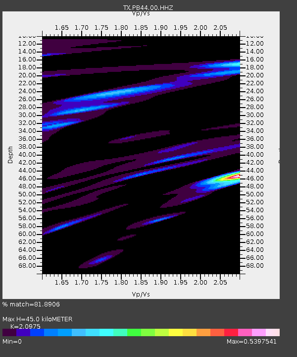
| Estimated Moho Depth: |
45.0 km |
| Estimated Crust Vp/Vs: |
2.10 |
| Assumed Crust Vp: |
6.121 km/s |
| Estimated Crust Vs: |
2.918 km/s |
| Estimated Crust Poisson's Ratio: |
0.35 |
|
| Radial Match: |
81.8906 % |
| Radial Bump: |
400 |
| Transverse Match: |
59.23567 % |
| Transverse Bump: |
313 |
| SOD ConfigId: |
33232451 |
| Insert Time: |
2023-12-25 07:06:23.351 +0000 |
| GWidth: |
2.5 |
| Max Bumps: |
400 |
| Tol: |
0.001 |
|

Signal To Noise
| Channel | StoN | STA | LTA |
| TX:PB44:00:HHZ:20231211T06:45:07.975983Z | 5.678825 | 1.00753E-6 | 1.7741874E-7 |
| TX:PB44:00:HHN:20231211T06:45:07.975983Z | 1.3784965 | 1.5933911E-7 | 1.1558905E-7 |
| TX:PB44:00:HHE:20231211T06:45:07.975983Z | 1.2408227 | 2.2728264E-7 | 1.8317093E-7 |
| Arrivals |
| Ps | 8.2 SECOND |
| PpPs | 22 SECOND |
| PsPs/PpSs | 31 SECOND |


