You are here: Home > Network List > XG92 - Rocky Mountain Front Stations List
> Station BTO outside Loveland, CO > Earthquake Result Viewer
BTO outside Loveland, CO - Earthquake Result Viewer
| Earthquake location: |
Near Coast Of Peru |
| Earthquake latitude/longitude: |
-10.4/-78.6 |
| Earthquake time(UTC): |
1992/07/17 (199) 18:46:00 GMT |
| Earthquake Depth: |
44 km |
| Earthquake Magnitude: |
5.5 MB, 5.4 MS |
| Earthquake Catalog/Contributor: |
WHDF/NEIC |
|
| Network: |
XG Rocky Mountain Front |
| Station: |
BTO outside Loveland, CO |
| Lat/Lon: |
40.39 N/105.20 W |
| Elevation: |
1609 m |
|
| Distance: |
56.2 deg |
| Az: |
335.668 deg |
| Baz: |
147.947 deg |
| Ray Param: |
0.06417665 |
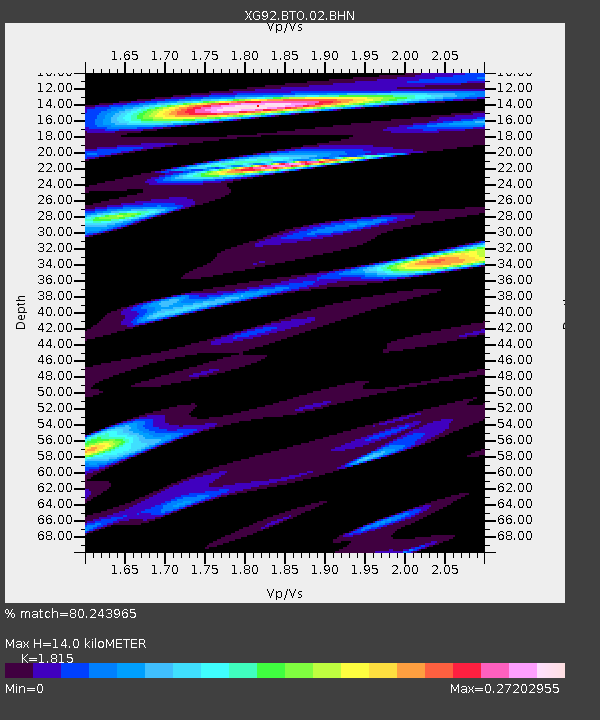
| Estimated Moho Depth: |
14.0 km |
| Estimated Crust Vp/Vs: |
1.82 |
| Assumed Crust Vp: |
6.306 km/s |
| Estimated Crust Vs: |
3.474 km/s |
| Estimated Crust Poisson's Ratio: |
0.28 |
|
| Radial Match: |
80.243965 % |
| Radial Bump: |
400 |
| Transverse Match: |
83.67789 % |
| Transverse Bump: |
400 |
| SOD ConfigId: |
3286 |
| Insert Time: |
2010-02-25 20:07:43.473 +0000 |
| GWidth: |
2.5 |
| Max Bumps: |
400 |
| Tol: |
0.001 |
|

Signal To Noise
| Channel | StoN | STA | LTA |
| XG:BTO:02:BHN:19920717T18:55:05.119019Z | 0.70792365 | 1.8908378E-5 | 2.6709631E-5 |
| XG:BTO:02:BHE:19920717T18:55:05.119019Z | 1.3696405 | 7.0332644E-5 | 5.1351173E-5 |
| XG:BTO:02:BHZ:19920717T18:55:05.119019Z | 3.7962651 | 2.685016E-4 | 7.072783E-5 |
| Arrivals |
| Ps | 1.9 SECOND |
| PpPs | 6.0 SECOND |
| PsPs/PpSs | 7.9 SECOND |


