You are here: Home > Network List > XG92 - Rocky Mountain Front Stations List
> Station BTO outside Loveland, CO > Earthquake Result Viewer
BTO outside Loveland, CO - Earthquake Result Viewer

| Earthquake location: |
Northern Peru |
| Earthquake latitude/longitude: |
-3.9/-76.6 |
| Earthquake time(UTC): |
1992/07/13 (195) 18:11:34 GMT |
| Earthquake Depth: |
100 km |
| Earthquake Magnitude: |
6.2 MB |
| Earthquake Catalog/Contributor: |
WHDF/NEIC |
|
| Network: |
XG Rocky Mountain Front |
| Station: |
BTO outside Loveland, CO |
| Lat/Lon: |
40.39 N/105.20 W |
| Elevation: |
1609 m |
|
| Distance: |
51.3 deg |
| Az: |
332.089 deg |
| Baz: |
142.305 deg |
| Ray Param: |
0.067186035 |
| Estimated Moho Depth: |
16.25 km |
| Estimated Crust Vp/Vs: |
2.05 |
| Assumed Crust Vp: |
6.306 km/s |
| Estimated Crust Vs: |
3.072 km/s |
| Estimated Crust Poisson's Ratio: |
0.34 |
|
| Radial Match: |
94.24067 % |
| Radial Bump: |
400 |
| Transverse Match: |
97.11483 % |
| Transverse Bump: |
371 |
| SOD ConfigId: |
3286 |
| Insert Time: |
2010-02-25 20:07:45.278 +0000 |
| GWidth: |
2.5 |
| Max Bumps: |
400 |
| Tol: |
0.001 |
|
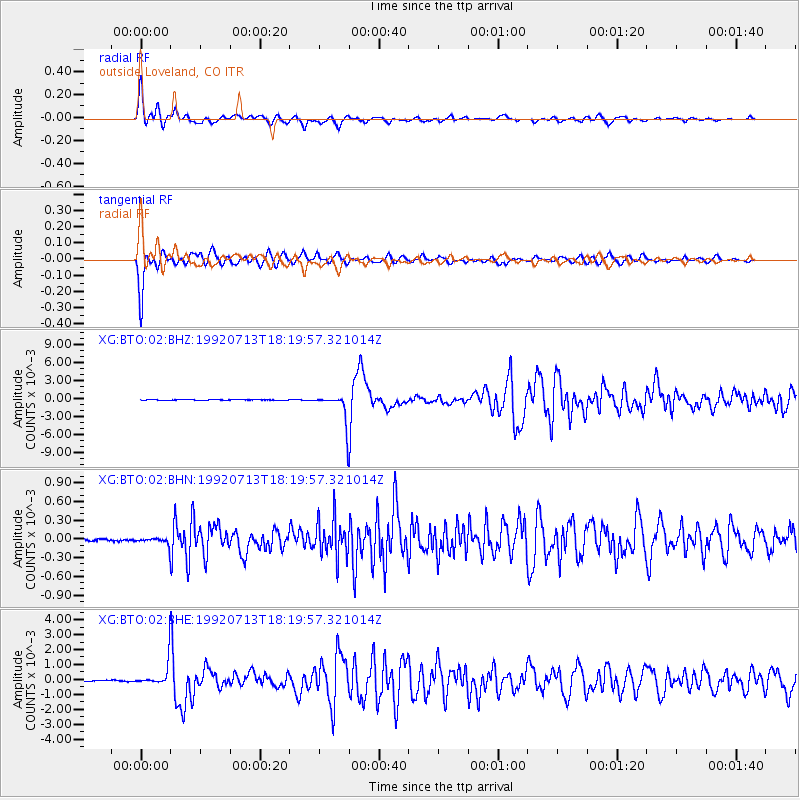
Signal To Noise
| Channel | StoN | STA | LTA |
| XG:BTO:02:BHN:19920713T18:19:57.321014Z | 3.0174572 | 6.349414E-5 | 2.1042266E-5 |
| XG:BTO:02:BHE:19920713T18:19:57.321014Z | 21.690128 | 8.471286E-4 | 3.9055954E-5 |
| XG:BTO:02:BHZ:19920713T18:19:57.321014Z | 43.430702 | 0.002360314 | 5.4346667E-5 |
| Arrivals |
| Ps | 2.8 SECOND |
| PpPs | 7.5 SECOND |
| PsPs/PpSs | 10 SECOND |


