You are here: Home > Network List > TX - Texas Seismological Network Stations List
> Station PB20 Ringtail SWD > Earthquake Result Viewer
PB20 Ringtail SWD - Earthquake Result Viewer
| Earthquake location: |
Near West Coast Of Honshu, Japan |
| Earthquake latitude/longitude: |
37.5/137.2 |
| Earthquake time(UTC): |
2024/01/01 (001) 07:10:10 GMT |
| Earthquake Depth: |
0.0 km |
| Earthquake Magnitude: |
7.4 Mi |
| Earthquake Catalog/Contributor: |
NEIC PDE/pt |
|
| Network: |
TX Texas Seismological Network |
| Station: |
PB20 Ringtail SWD |
| Lat/Lon: |
31.63 N/104.06 W |
| Elevation: |
1022 m |
|
| Distance: |
90.6 deg |
| Az: |
48.417 deg |
| Baz: |
315.782 deg |
| Ray Param: |
0.041696604 |
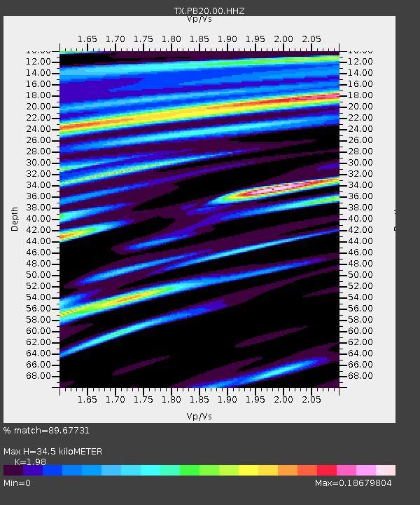
| Estimated Moho Depth: |
34.5 km |
| Estimated Crust Vp/Vs: |
1.98 |
| Assumed Crust Vp: |
6.361 km/s |
| Estimated Crust Vs: |
3.212 km/s |
| Estimated Crust Poisson's Ratio: |
0.33 |
|
| Radial Match: |
89.67731 % |
| Radial Bump: |
400 |
| Transverse Match: |
67.28551 % |
| Transverse Bump: |
400 |
| SOD ConfigId: |
33437571 |
| Insert Time: |
2024-01-15 08:08:50.895 +0000 |
| GWidth: |
2.5 |
| Max Bumps: |
400 |
| Tol: |
0.001 |
|

Signal To Noise
| Channel | StoN | STA | LTA |
| TX:PB20:00:HHZ:20240101T07:22:42.310974Z | 1.4106451 | 1.1032183E-6 | 7.8206654E-7 |
| TX:PB20:00:HHN:20240101T07:22:42.310974Z | 1.021837 | 5.647874E-7 | 5.527177E-7 |
| TX:PB20:00:HHE:20240101T07:22:42.310974Z | 1.0990968 | 1.0956586E-6 | 9.968718E-7 |
| Arrivals |
| Ps | 5.4 SECOND |
| PpPs | 16 SECOND |
| PsPs/PpSs | 21 SECOND |


