You are here: Home > Network List > TX - Texas Seismological Network Stations List
> Station PB20 Ringtail SWD > Earthquake Result Viewer
PB20 Ringtail SWD - Earthquake Result Viewer
| Earthquake location: |
Near West Coast Of Honshu, Japan |
| Earthquake latitude/longitude: |
37.6/137.4 |
| Earthquake time(UTC): |
2024/01/01 (001) 09:03:49 GMT |
| Earthquake Depth: |
10 km |
| Earthquake Magnitude: |
5.5 mb |
| Earthquake Catalog/Contributor: |
NEIC PDE/us |
|
| Network: |
TX Texas Seismological Network |
| Station: |
PB20 Ringtail SWD |
| Lat/Lon: |
31.63 N/104.06 W |
| Elevation: |
1022 m |
|
| Distance: |
90.4 deg |
| Az: |
48.529 deg |
| Baz: |
315.728 deg |
| Ray Param: |
0.041705202 |
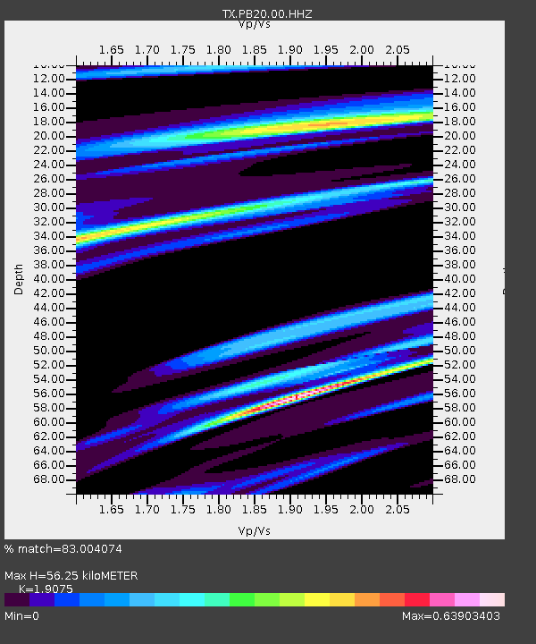
| Estimated Moho Depth: |
56.25 km |
| Estimated Crust Vp/Vs: |
1.91 |
| Assumed Crust Vp: |
6.361 km/s |
| Estimated Crust Vs: |
3.335 km/s |
| Estimated Crust Poisson's Ratio: |
0.31 |
|
| Radial Match: |
83.004074 % |
| Radial Bump: |
229 |
| Transverse Match: |
88.592285 % |
| Transverse Bump: |
263 |
| SOD ConfigId: |
33437571 |
| Insert Time: |
2024-01-15 09:32:39.238 +0000 |
| GWidth: |
2.5 |
| Max Bumps: |
400 |
| Tol: |
0.001 |
|

Signal To Noise
| Channel | StoN | STA | LTA |
| TX:PB20:00:HHZ:20240101T09:16:19.140989Z | 1.7981249 | 3.0628582E-6 | 1.7033623E-6 |
| TX:PB20:00:HHN:20240101T09:16:19.140989Z | 2.5715892 | 2.43461E-6 | 9.467336E-7 |
| TX:PB20:00:HHE:20240101T09:16:19.140989Z | 2.4019825 | 4.731968E-6 | 1.970026E-6 |
| Arrivals |
| Ps | 8.2 SECOND |
| PpPs | 25 SECOND |
| PsPs/PpSs | 33 SECOND |


