You are here: Home > Network List > JP - Japan Meteorological Agency Seismic Network Stations List
> Station JEM Erimo > Earthquake Result Viewer
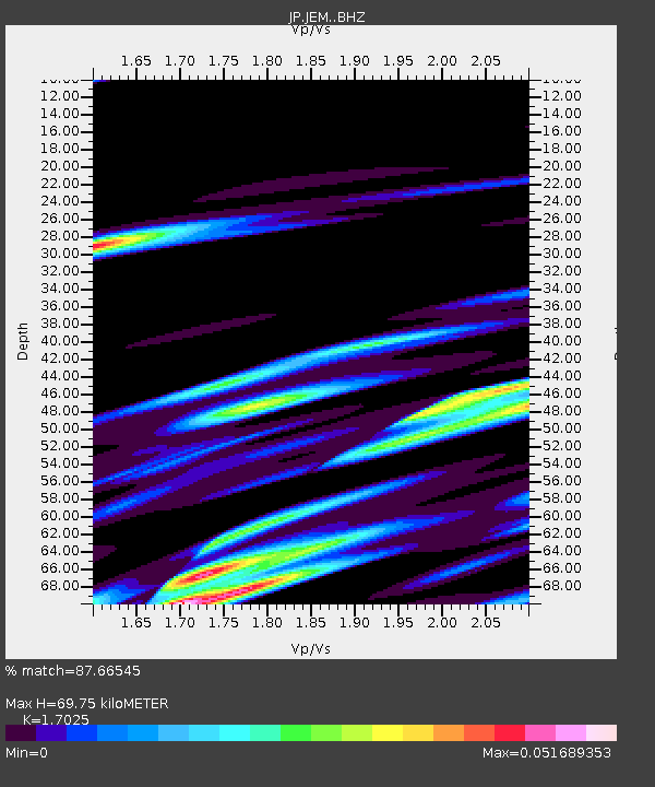
JEM Erimo - Earthquake Result Viewer
| Earthquake location: |
Kyrgyzstan-Xinjiang Border Reg. |
| Earthquake latitude/longitude: |
41.3/78.6 |
| Earthquake time(UTC): |
2024/01/22 (022) 18:09:04 GMT |
| Earthquake Depth: |
13 km |
| Earthquake Magnitude: |
7.0 Mww |
| Earthquake Catalog/Contributor: |
NEIC PDE/us |
|
| Network: |
JP Japan Meteorological Agency Seismic Network |
| Station: |
JEM Erimo |
| Lat/Lon: |
42.02 N/143.15 E |
| Elevation: |
40 m |
|
| Distance: |
47.2 deg |
| Az: |
66.536 deg |
| Baz: |
291.88 deg |
| Ray Param: |
0.0701754 |
| Estimated Moho Depth: |
69.75 km |
| Estimated Crust Vp/Vs: |
1.70 |
| Assumed Crust Vp: |
6.461 km/s |
| Estimated Crust Vs: |
3.795 km/s |
| Estimated Crust Poisson's Ratio: |
0.24 |
|
| Radial Match: |
87.66545 % |
| Radial Bump: |
380 |
| Transverse Match: |
97.98197 % |
| Transverse Bump: |
153 |
| SOD ConfigId: |
33437571 |
| Insert Time: |
2024-02-05 18:26:08.563 +0000 |
| GWidth: |
2.5 |
| Max Bumps: |
400 |
| Tol: |
0.001 |
|

Signal To Noise
| Channel | StoN | STA | LTA |
| JP:JEM: :BHZ:20240122T18:17:05.550007Z | 2.153193 | 6.060486E-8 | 2.8146507E-8 |
| JP:JEM: :BHN:20240122T18:17:05.550007Z | 1.6326048 | 2.1822562E-8 | 1.3366714E-8 |
| JP:JEM: :BHE:20240122T18:17:05.550007Z | 1.5525498 | 1.3898018E-8 | 8.951737E-9 |
| Arrivals |
| Ps | 8.1 SECOND |
| PpPs | 27 SECOND |
| PsPs/PpSs | 35 SECOND |


