You are here: Home > Network List > IC - New China Digital Seismograph Network Stations List
> Station HIA Hailar, Neimenggu Autonomous Region, China > Earthquake Result Viewer
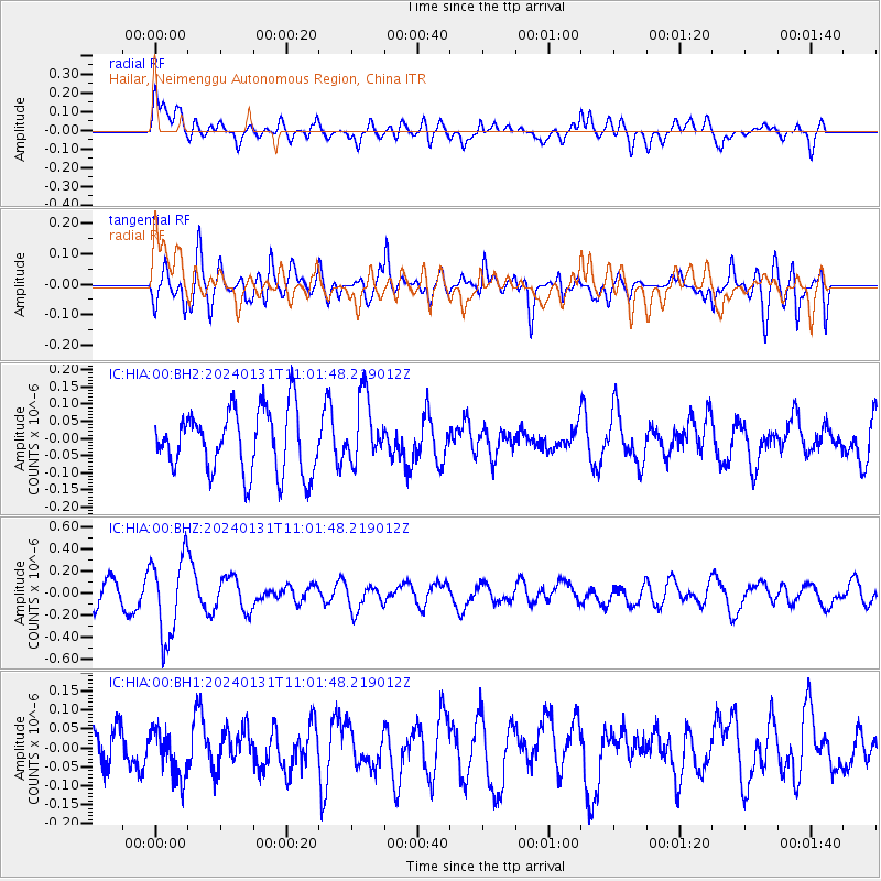
HIA Hailar, Neimenggu Autonomous Region, China - Earthquake Result Viewer
*The percent match for this event was below the threshold and hence no stack was calculated.
| Earthquake location: |
South Of Fiji Islands |
| Earthquake latitude/longitude: |
-22.8/-177.1 |
| Earthquake time(UTC): |
2024/01/31 (031) 10:49:36 GMT |
| Earthquake Depth: |
185 km |
| Earthquake Magnitude: |
5.8 mww |
| Earthquake Catalog/Contributor: |
NEIC PDE/us |
|
| Network: |
IC New China Digital Seismograph Network |
| Station: |
HIA Hailar, Neimenggu Autonomous Region, China |
| Lat/Lon: |
49.27 N/119.74 E |
| Elevation: |
620 m |
|
| Distance: |
91.0 deg |
| Az: |
324.244 deg |
| Baz: |
124.61 deg |
| Ray Param: |
$rayparam |
*The percent match for this event was below the threshold and hence was not used in the summary stack. |
|
| Radial Match: |
64.97345 % |
| Radial Bump: |
400 |
| Transverse Match: |
67.1883 % |
| Transverse Bump: |
400 |
| SOD ConfigId: |
33437571 |
| Insert Time: |
2024-02-14 11:03:31.815 +0000 |
| GWidth: |
2.5 |
| Max Bumps: |
400 |
| Tol: |
0.001 |
|
Signal To Noise
| Channel | StoN | STA | LTA |
| IC:HIA:00:BHZ:20240131T11:01:48.219012Z | 3.106849 | 3.6877705E-7 | 1.186981E-7 |
| IC:HIA:00:BH1:20240131T11:01:48.219012Z | 1.2714152 | 6.288399E-8 | 4.9459835E-8 |
| IC:HIA:00:BH2:20240131T11:01:48.219012Z | 1.0578456 | 9.626733E-8 | 9.100319E-8 |
| Arrivals |
| Ps | |
| PpPs | |
| PsPs/PpSs | |


