You are here: Home > Network List > IC - New China Digital Seismograph Network Stations List
> Station HIA Hailar, Neimenggu Autonomous Region, China > Earthquake Result Viewer
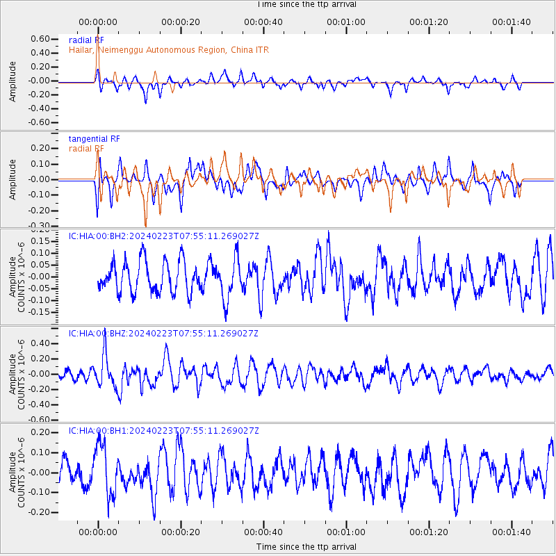
HIA Hailar, Neimenggu Autonomous Region, China - Earthquake Result Viewer
*The percent match for this event was below the threshold and hence no stack was calculated.
| Earthquake location: |
Southern Sumatra, Indonesia |
| Earthquake latitude/longitude: |
-0.7/98.5 |
| Earthquake time(UTC): |
2024/02/23 (054) 07:46:26 GMT |
| Earthquake Depth: |
20 km |
| Earthquake Magnitude: |
5.3 Mww |
| Earthquake Catalog/Contributor: |
NEIC PDE/us |
|
| Network: |
IC New China Digital Seismograph Network |
| Station: |
HIA Hailar, Neimenggu Autonomous Region, China |
| Lat/Lon: |
49.27 N/119.74 E |
| Elevation: |
620 m |
|
| Distance: |
53.0 deg |
| Az: |
17.297 deg |
| Baz: |
206.994 deg |
| Ray Param: |
$rayparam |
*The percent match for this event was below the threshold and hence was not used in the summary stack. |
|
| Radial Match: |
73.7043 % |
| Radial Bump: |
400 |
| Transverse Match: |
51.88195 % |
| Transverse Bump: |
400 |
| SOD ConfigId: |
33437571 |
| Insert Time: |
2024-03-08 07:52:54.545 +0000 |
| GWidth: |
2.5 |
| Max Bumps: |
400 |
| Tol: |
0.001 |
|
Signal To Noise
| Channel | StoN | STA | LTA |
| IC:HIA:00:BHZ:20240223T07:55:11.269027Z | 3.9514754 | 2.1538541E-7 | 5.4507595E-8 |
| IC:HIA:00:BH1:20240223T07:55:11.269027Z | 2.123602 | 1.3140382E-7 | 6.1877806E-8 |
| IC:HIA:00:BH2:20240223T07:55:11.269027Z | 1.3629876 | 8.79292E-8 | 6.45121E-8 |
| Arrivals |
| Ps | |
| PpPs | |
| PsPs/PpSs | |


