You are here: Home > Network List > IC - New China Digital Seismograph Network Stations List
> Station HIA Hailar, Neimenggu Province, China > Earthquake Result Viewer
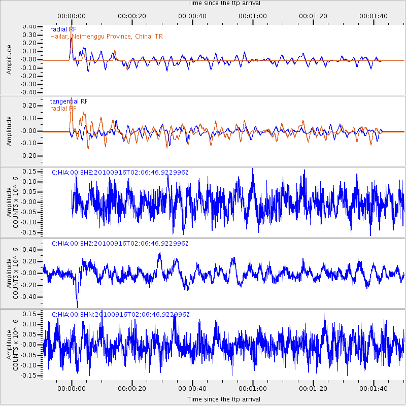
HIA Hailar, Neimenggu Province, China - Earthquake Result Viewer
*The percent match for this event was below the threshold and hence no stack was calculated.
| Earthquake location: |
Tonga Islands |
| Earthquake latitude/longitude: |
-16.0/-174.0 |
| Earthquake time(UTC): |
2010/09/16 (259) 01:54:40 GMT |
| Earthquake Depth: |
84 km |
| Earthquake Magnitude: |
5.5 MB, 5.8 MW, 5.8 MW |
| Earthquake Catalog/Contributor: |
WHDF/NEIC |
|
| Network: |
IC New China Digital Seismograph Network |
| Station: |
HIA Hailar, Neimenggu Province, China |
| Lat/Lon: |
49.27 N/119.74 E |
| Elevation: |
610 m |
|
| Distance: |
87.4 deg |
| Az: |
323.099 deg |
| Baz: |
118.186 deg |
| Ray Param: |
$rayparam |
*The percent match for this event was below the threshold and hence was not used in the summary stack. |
|
| Radial Match: |
65.90718 % |
| Radial Bump: |
400 |
| Transverse Match: |
49.13034 % |
| Transverse Bump: |
400 |
| SOD ConfigId: |
319893 |
| Insert Time: |
2011-01-20 09:29:44.944 +0000 |
| GWidth: |
2.5 |
| Max Bumps: |
400 |
| Tol: |
0.001 |
|
Signal To Noise
| Channel | StoN | STA | LTA |
| IC:HIA:00:BHZ:20100916T02:06:46.922996Z | 3.1613739 | 1.9566501E-7 | 6.18924E-8 |
| IC:HIA:00:BHN:20100916T02:06:46.922996Z | 1.4295547 | 6.043864E-8 | 4.227795E-8 |
| IC:HIA:00:BHE:20100916T02:06:46.922996Z | 1.2430924 | 6.1819485E-8 | 4.9730403E-8 |
| Arrivals |
| Ps | |
| PpPs | |
| PsPs/PpSs | |


