You are here: Home > Network List > KS - Korea National Seismograph Network- KMA Stations List
> Station SH2B Seawha, South Korea > Earthquake Result Viewer
SH2B Seawha, South Korea - Earthquake Result Viewer
| Earthquake location: |
Northern Molucca Sea |
| Earthquake latitude/longitude: |
2.7/127.1 |
| Earthquake time(UTC): |
2024/04/09 (100) 09:48:01 GMT |
| Earthquake Depth: |
35 km |
| Earthquake Magnitude: |
6.6 mww |
| Earthquake Catalog/Contributor: |
NEIC PDE/us |
|
| Network: |
KS Korea National Seismograph Network- KMA |
| Station: |
SH2B Seawha, South Korea |
| Lat/Lon: |
38.27 N/128.25 E |
| Elevation: |
432 m |
|
| Distance: |
35.4 deg |
| Az: |
1.574 deg |
| Baz: |
181.997 deg |
| Ray Param: |
0.07717784 |
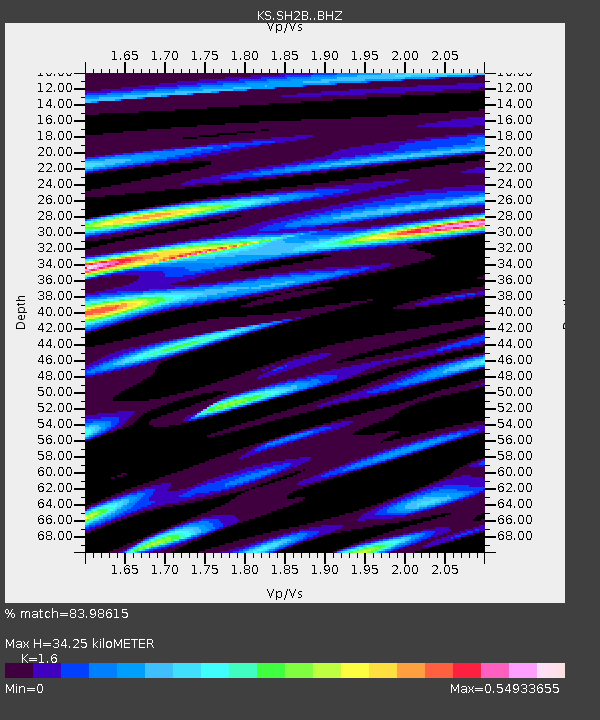
| Estimated Moho Depth: |
34.25 km |
| Estimated Crust Vp/Vs: |
1.60 |
| Assumed Crust Vp: |
6.183 km/s |
| Estimated Crust Vs: |
3.864 km/s |
| Estimated Crust Poisson's Ratio: |
0.18 |
|
| Radial Match: |
83.98615 % |
| Radial Bump: |
400 |
| Transverse Match: |
92.5487 % |
| Transverse Bump: |
317 |
| SOD ConfigId: |
34025071 |
| Insert Time: |
2024-04-23 10:02:13.094 +0000 |
| GWidth: |
2.5 |
| Max Bumps: |
400 |
| Tol: |
0.001 |
|

Signal To Noise
| Channel | StoN | STA | LTA |
| KS:SH2B: :BHZ:20240409T09:54:23.868995Z | 6.044788 | 3.820671E-6 | 6.3206033E-7 |
| KS:SH2B: :BHN:20240409T09:54:23.868995Z | 8.266355 | 2.5847232E-6 | 3.1267993E-7 |
| KS:SH2B: :BHE:20240409T09:54:23.868995Z | 2.275694 | 6.349635E-7 | 2.7901973E-7 |
| Arrivals |
| Ps | 3.6 SECOND |
| PpPs | 13 SECOND |
| PsPs/PpSs | 17 SECOND |


