You are here: Home > Network List > AV - Alaska Volcano Observatory Stations List
> Station KAKN KAKN - Katmai Volcanic Cluster, Alaska > Earthquake Result Viewer
KAKN KAKN - Katmai Volcanic Cluster, Alaska - Earthquake Result Viewer
| Earthquake location: |
Gulf Of California |
| Earthquake latitude/longitude: |
24.7/-109.2 |
| Earthquake time(UTC): |
2010/10/21 (294) 17:53:13 GMT |
| Earthquake Depth: |
10 km |
| Earthquake Magnitude: |
6.2 MB, 6.8 MS, 6.7 MW, 6.7 MW |
| Earthquake Catalog/Contributor: |
WHDF/NEIC |
|
| Network: |
AV Alaska Volcano Observatory |
| Station: |
KAKN KAKN - Katmai Volcanic Cluster, Alaska |
| Lat/Lon: |
58.30 N/155.06 W |
| Elevation: |
1049 m |
|
| Distance: |
46.6 deg |
| Az: |
328.539 deg |
| Baz: |
115.97 deg |
| Ray Param: |
0.0705409 |
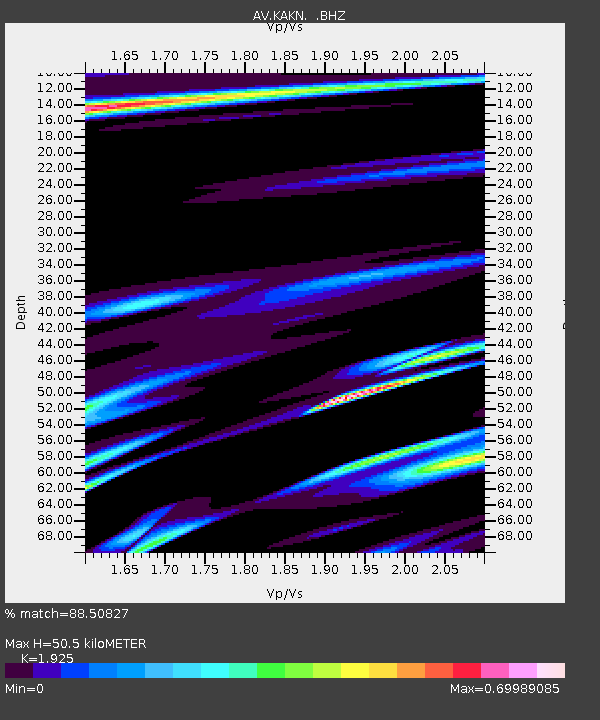
| Estimated Moho Depth: |
50.5 km |
| Estimated Crust Vp/Vs: |
1.92 |
| Assumed Crust Vp: |
6.438 km/s |
| Estimated Crust Vs: |
3.345 km/s |
| Estimated Crust Poisson's Ratio: |
0.32 |
|
| Radial Match: |
88.50827 % |
| Radial Bump: |
400 |
| Transverse Match: |
67.63337 % |
| Transverse Bump: |
400 |
| SOD ConfigId: |
339645 |
| Insert Time: |
2011-02-17 09:43:40.461 +0000 |
| GWidth: |
2.5 |
| Max Bumps: |
400 |
| Tol: |
0.001 |
|

Signal To Noise
| Channel | StoN | STA | LTA |
| AV:KAKN: :BHZ:20101021T18:01:10.320011Z | 3.923433 | 2.032445E-6 | 5.180272E-7 |
| AV:KAKN: :BHN:20101021T18:01:10.320011Z | 6.680912 | 2.5405036E-6 | 3.80263E-7 |
| AV:KAKN: :BHE:20101021T18:01:10.320011Z | 5.1387525 | 2.7212568E-6 | 5.295559E-7 |
| Arrivals |
| Ps | 7.7 SECOND |
| PpPs | 22 SECOND |
| PsPs/PpSs | 29 SECOND |


