You are here: Home > Network List > IC - New China Digital Seismograph Network Stations List
> Station HIA Hailar, Neimenggu Province, China > Earthquake Result Viewer
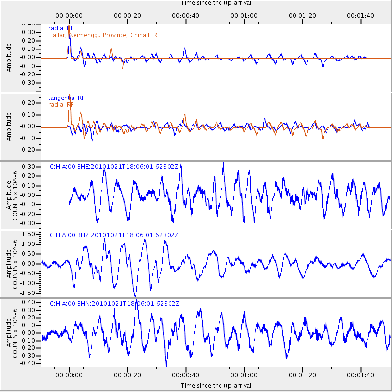
HIA Hailar, Neimenggu Province, China - Earthquake Result Viewer
*The percent match for this event was below the threshold and hence no stack was calculated.
| Earthquake location: |
Gulf Of California |
| Earthquake latitude/longitude: |
24.7/-109.2 |
| Earthquake time(UTC): |
2010/10/21 (294) 17:53:13 GMT |
| Earthquake Depth: |
10 km |
| Earthquake Magnitude: |
6.2 MB, 6.8 MS, 6.7 MW, 6.7 MW |
| Earthquake Catalog/Contributor: |
WHDF/NEIC |
|
| Network: |
IC New China Digital Seismograph Network |
| Station: |
HIA Hailar, Neimenggu Province, China |
| Lat/Lon: |
49.27 N/119.74 E |
| Elevation: |
620 m |
|
| Distance: |
94.5 deg |
| Az: |
330.324 deg |
| Baz: |
43.437 deg |
| Ray Param: |
$rayparam |
*The percent match for this event was below the threshold and hence was not used in the summary stack. |
|
| Radial Match: |
78.15135 % |
| Radial Bump: |
400 |
| Transverse Match: |
56.578857 % |
| Transverse Bump: |
400 |
| SOD ConfigId: |
339645 |
| Insert Time: |
2011-02-17 09:44:47.290 +0000 |
| GWidth: |
2.5 |
| Max Bumps: |
400 |
| Tol: |
0.001 |
|
Signal To Noise
| Channel | StoN | STA | LTA |
| IC:HIA:00:BHZ:20101021T18:06:01.62302Z | 2.9149015 | 4.9274445E-7 | 1.6904325E-7 |
| IC:HIA:00:BHN:20101021T18:06:01.62302Z | 1.0623398 | 8.585922E-8 | 8.082087E-8 |
| IC:HIA:00:BHE:20101021T18:06:01.62302Z | 0.71006924 | 8.625629E-8 | 1.2147588E-7 |
| Arrivals |
| Ps | |
| PpPs | |
| PsPs/PpSs | |


