You are here: Home > Network List > PR - Puerto Rico Seismic Network (PRSN) & Puerto Rico Strong Motion Program (PRSMP) Stations List
> Station CPD Yabucoa, Puerto Rico(T4124) > Earthquake Result Viewer
CPD Yabucoa, Puerto Rico(T4124) - Earthquake Result Viewer
| Earthquake location: |
Gulf Of California |
| Earthquake latitude/longitude: |
24.7/-109.2 |
| Earthquake time(UTC): |
2010/10/21 (294) 17:53:13 GMT |
| Earthquake Depth: |
10 km |
| Earthquake Magnitude: |
6.2 MB, 6.8 MS, 6.7 MW, 6.7 MW |
| Earthquake Catalog/Contributor: |
WHDF/NEIC |
|
| Network: |
PR Puerto Rico Seismic Network (PRSN) & Puerto Rico Strong Motion Program (PRSMP) |
| Station: |
CPD Yabucoa, Puerto Rico(T4124) |
| Lat/Lon: |
18.04 N/65.92 W |
| Elevation: |
386 m |
|
| Distance: |
40.7 deg |
| Az: |
90.7 deg |
| Baz: |
287.066 deg |
| Ray Param: |
0.07425651 |
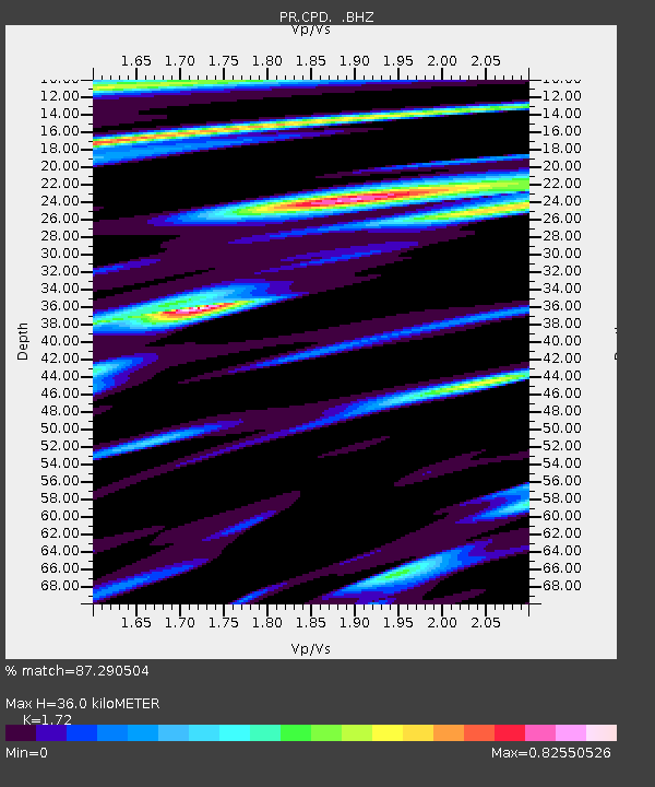
| Estimated Moho Depth: |
36.0 km |
| Estimated Crust Vp/Vs: |
1.72 |
| Assumed Crust Vp: |
5.14 km/s |
| Estimated Crust Vs: |
2.988 km/s |
| Estimated Crust Poisson's Ratio: |
0.24 |
|
| Radial Match: |
87.290504 % |
| Radial Bump: |
327 |
| Transverse Match: |
89.45591 % |
| Transverse Bump: |
355 |
| SOD ConfigId: |
339645 |
| Insert Time: |
2011-02-17 09:46:20.242 +0000 |
| GWidth: |
2.5 |
| Max Bumps: |
400 |
| Tol: |
0.001 |
|

Signal To Noise
| Channel | StoN | STA | LTA |
| PR:CPD: :BHZ:20101021T18:00:22.720005Z | 44.29569 | 1.0418137E-5 | 2.3519529E-7 |
| PR:CPD: :BHN:20101021T18:00:22.720005Z | 15.4882345 | 3.868288E-6 | 2.4975657E-7 |
| PR:CPD: :BHE:20101021T18:00:22.720005Z | 11.767156 | 5.386951E-6 | 4.5779555E-7 |
| Arrivals |
| Ps | 5.3 SECOND |
| PpPs | 18 SECOND |
| PsPs/PpSs | 23 SECOND |


