
Station PR CPD - Yabucoa, Puerto Rico(T4124)
Network: PR - Puerto Rico Seismic Network (PRSN) & Puerto Rico Strong Motion Program (PRSMP)
Nearby stations (2 deg radius)
| Station | Name | (Lat, Lon) | Start / End | Elevation |
| CPD | Yabucoa, Puerto Rico(T4124) | (18.04, -65.92) | 2000-12-17 / 2499-01-01 | 386 m |
| Crust2 Type: | B7,thick melt affected o.c., 1 km seds. |
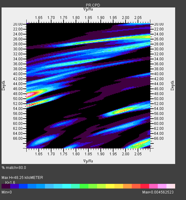
| Thickness Estimate: | 48 km |
| Thickness StdDev: | 16 km |
| Vp/Vs Estimate: | 1.60 |
| Vp/Vs StdDev: | 0.19 |
| Vs Estimate: | 3.212 km/s |
| Poisson's Ratio: | 0.18 |
| Peak Value: | 0.00 |
| Assumed Vp: | 5.14 km/s |
| Ps Weight: | 0.33333334 |
| PpPs Weight: | 0.33333334 |
| PsPs Weight: | 0.33333328 |
| Residual Complexity: | 0.838 |
| Nearby stations H: | +- |
| (2.0 deg) Vp/Vs: | +- |
4 with match > 90% ( 13.793103 %) and 11 with match > 80% ( 37.931034 %) out of 29.
Download stack as xyz text file.
Azimuth Distribution of Events:
Prior Results for this Station
| Study | Thickness | Vp/Vs | Vp | Vs | Poissons Ratio | Extra |
| EARS | 48 km | 1.60 | 5.14 km/s | 3.212 km/s | 0.18 | |
| Crust2.0 | 24 km | 1.98 | 5.14 km/s | 2.6 km/s | 0.33 | B7,thick melt affected o.c., 1 km seds. |
| Global Maxima | 48 km | 1.60 | 5.14 km/s | 3.212 km/s | 0.18 | amp=0.004562523 |
| Local Maxima 1 | 53 km | 1.60 | 5.14 km/s | 3.207 km/s | 0.18 | amp=0.004332067 |
| Local Maxima 2 | 55 km | 1.99 | 5.14 km/s | 2.583 km/s | 0.33 | amp=0.0034090306 |
| Local Maxima 3 | 68 km | 2.05 | 5.14 km/s | 2.507 km/s | 0.34 | amp=0.0032278548 |
| Local Maxima 4 | 26 km | 1.93 | 5.14 km/s | 2.656 km/s | 0.32 | amp=0.0031536643 |
| Predicted Arrivals for vertical incidence (zero ray parameter) | |
| Ps | 5.63 SECOND |
| PpPs | 24.41 SECOND |
| PsPs/PpSs | 30.04 SECOND |
Events Processed for this Station
Download zip of receiver functions as SAC
Plot maxima for each earthquake.
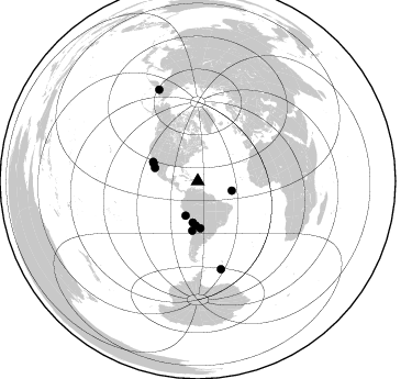
Events Used in the Stack
(11 events)| Radial Match | Distance | Baz | FERegion | Time | Lat/Lon | Depth | Magnitude |
| 99.423035 | 40.2 deg | 182.832 deg | Chile-Bolivia Border Region | 2005/11/17 19:26:56 GMT | (-22.3, -67.9) | 163 km | 6.0 MB, 6.9 MW, 6.8 MW |
| 92.24998 | 44.2 deg | 293.292 deg | Gulf Of California | 2009/08/03 17:59:56 GMT | (29.0, -112.9) | 10 km | 6.2 MB, 6.9 MW, 6.8 MW |
| 91.58978 | 37.7 deg | 187.06 deg | Near Coast Of Northern Chile | 2009/04/17 02:08:08 GMT | (-19.6, -70.5) | 25 km | 5.8 MB, 5.8 MS, 6.1 MW, 6.1 MW |
| 90.54056 | 33.0 deg | 199.46 deg | Near Coast Of Peru | 2006/10/20 10:48:56 GMT | (-13.5, -76.7) | 23 km | 5.9 MB, 6.6 MS, 6.7 MW, 6.6 MW |
| 87.290504 | 40.7 deg | 287.066 deg | Gulf Of California | 2010/10/21 17:53:13 GMT | (24.7, -109.2) | 10 km | 6.2 MB, 6.8 MS, 6.7 MW, 6.7 MW |
| 84.56026 | 32.0 deg | 105.453 deg | Central Mid-Atlantic Ridge | 2008/05/23 19:35:34 GMT | (7.3, -34.9) | 9.0 km | 6.0 MB, 6.4 MS, 6.5 MW, 6.5 MW |
| 83.436134 | 82.8 deg | 165.12 deg | Scotia Sea | 2006/08/20 03:41:47 GMT | (-61.0, -34.4) | 10 km | 6.4 MB, 6.8 MS, 7.0 MW, 7.0 MW |
| 83.347374 | 43.5 deg | 292.094 deg | Gulf Of California | 2006/01/04 08:32:32 GMT | (28.2, -112.1) | 14 km | 6.1 MB, 6.7 MS, 6.6 MW, 6.5 MW |
| 83.21466 | 90.6 deg | 337.055 deg | Eastern Siberia, Russia | 2006/04/20 23:25:02 GMT | (60.9, 167.1) | 22 km | 6.8 MB, 7.6 MS, 7.6 MW, 7.3 MW |
| 82.613815 | 45.0 deg | 186.363 deg | Near Coast Of Northern Chile | 2006/04/30 19:17:17 GMT | (-27.0, -71.0) | 27 km | 6.0 MB, 6.4 MS, 6.7 MW, 6.6 MW |
| 82.38034 | 42.8 deg | 176.735 deg | Salta Province, Argentina | 2005/03/21 12:23:54 GMT | (-25.0, -63.5) | 579 km | 6.1 MB, 6.9 MW, 6.9 MW |
Losers
(18 events)| Radial Match | Distance | Baz | FERegion | Time | Lat/Lon | Depth | Magnitude | Reason |
| 99.51624 | 40.0 deg | 183.32 deg | Northern Chile | 2010/07/12 00:11:21 GMT | (-22.1, -68.2) | 115 km | 6.1 MB, 6.3 MW, 6.2 MW | |
| 80.27161 | 55.2 deg | 187.302 deg | Near Coast Of Central Chile | 2010/09/09 07:28:01 GMT | (-37.0, -73.4) | 16 km | 5.8 MB, 6.0 MS, 6.2 MW, 6.2 MW | |
| 79.89226 | 84.1 deg | 161.557 deg | South Sandwich Islands Region | 2009/04/16 14:57:06 GMT | (-60.2, -26.9) | 20 km | 6.2 MB, 6.8 MS, 6.7 MW, 6.7 MW | |
| 77.6729 | 40.6 deg | 286.733 deg | Gulf Of California | 2010/10/20 06:58:13 GMT | (24.5, -109.0) | 10 km | 5.5 MB, 5.6 MS, 5.8 MW, 5.7 MW | |
| 73.95771 | 87.6 deg | 323.734 deg | Andreanof Islands, Aleutian Is. | 2010/10/08 03:26:13 GMT | (51.4, -175.4) | 19 km | 6.2 MB, 6.3 MS, 6.4 MW, 6.2 MW | |
| 69.54336 | 32.8 deg | 188.713 deg | Central Peru | 2010/09/13 07:15:49 GMT | (-14.6, -70.8) | 180 km | 5.6 MB, 5.9 MW, 5.8 MW | |
| 68.705185 | 40.3 deg | 285.716 deg | Gulf Of California | 2009/01/05 10:59:30 GMT | (23.8, -108.8) | 10 km | 5.7 MB, 5.2 MS, 5.5 MW, 5.5 MW | |
| 65.83148 | 33.5 deg | 185.899 deg | Peru-Bolivia Border Region | 2009/09/30 19:03:17 GMT | (-15.6, -69.3) | 255 km | 5.9 MB, 5.8 MW | |
| 63.082447 | 75.4 deg | 179.98 deg | Drake Passage | 2010/01/17 12:00:01 GMT | (-57.7, -65.9) | 5.0 km | 6.0 MB, 6.0 MS, 6.3 MW, 6.3 MW | |
| 61.783623 | 65.6 deg | 351.387 deg | Arctic Ocean | 2008/11/18 04:52:51 GMT | (79.7, -115.5) | 10 km | 5.6 ML, 5.3 MB | |
| 57.08264 | 33.5 deg | 50.996 deg | Azores Islands Region | 2009/11/04 18:41:44 GMT | (36.2, -33.9) | 10 km | 5.7 MB, 5.6 MS, 5.9 MW, 5.8 MW | |
| 56.762577 | 84.0 deg | 322.985 deg | Fox Islands, Aleutian Islands | 2008/03/11 14:37:10 GMT | (52.2, -169.5) | 16 km | 5.5 MB, 5.3 MS, 5.6 MW, 5.5 MW | |
| 55.21011 | 40.3 deg | 278.719 deg | Revilla Gigedo Islands Region | 2009/09/18 18:46:08 GMT | (19.3, -108.5) | 10 km | 5.6 MW, 5.2 MB, 5.6 MW | |
| 53.407394 | 83.7 deg | 323.434 deg | Fox Islands, Aleutian Islands | 2010/07/28 11:31:46 GMT | (52.7, -169.4) | 10 km | 5.6 MW, 5.2 MS, 5.2 MB, 5.1 ML | |
| 49.18217 | 39.1 deg | 277.8 deg | Off Coast Of Jalisco, Mexico | 2010/08/24 02:11:59 GMT | (18.8, -107.2) | 10 km | 5.5 MB, 5.6 MS, 6.1 MW, 6.0 MW | |
| 48.643238 | 44.6 deg | 176.572 deg | Santiago Del Estero Prov., Arg. | 2008/09/03 11:25:14 GMT | (-26.7, -63.2) | 570 km | 5.9 MB, 6.3 MW, 6.3 MW | |
| 43.832687 | 84.1 deg | 158.388 deg | South Sandwich Islands Region | 2008/06/30 06:17:44 GMT | (-58.2, -22.1) | 19 km | 6.1 MB, 6.7 MS, 7.0 MW, 6.9 MW | |
| 43.350597 | 78.5 deg | 359.868 deg | North Of Severnaya Zemlya | 2008/08/13 08:35:02 GMT | (83.6, 115.2) | 10 km | 5.5 MB, 4.7 MS, 5.4 MW, 5.4 MW |
