You are here: Home > Network List > SB - UC Santa Barbara Engineering Seismology Network () Stations List
> Station CPSLO CalPoly San Luis Obispo > Earthquake Result Viewer
CPSLO CalPoly San Luis Obispo - Earthquake Result Viewer
| Earthquake location: |
Rat Islands, Aleutian Islands |
| Earthquake latitude/longitude: |
51.6/178.6 |
| Earthquake time(UTC): |
2022/12/14 (348) 18:40:26 GMT |
| Earthquake Depth: |
73 km |
| Earthquake Magnitude: |
6.3 Mww |
| Earthquake Catalog/Contributor: |
NEIC PDE/us |
|
| Network: |
SB UC Santa Barbara Engineering Seismology Network () |
| Station: |
CPSLO CalPoly San Luis Obispo |
| Lat/Lon: |
35.30 N/120.67 W |
| Elevation: |
88 m |
|
| Distance: |
45.6 deg |
| Az: |
86.322 deg |
| Baz: |
310.48 deg |
| Ray Param: |
0.07094033 |
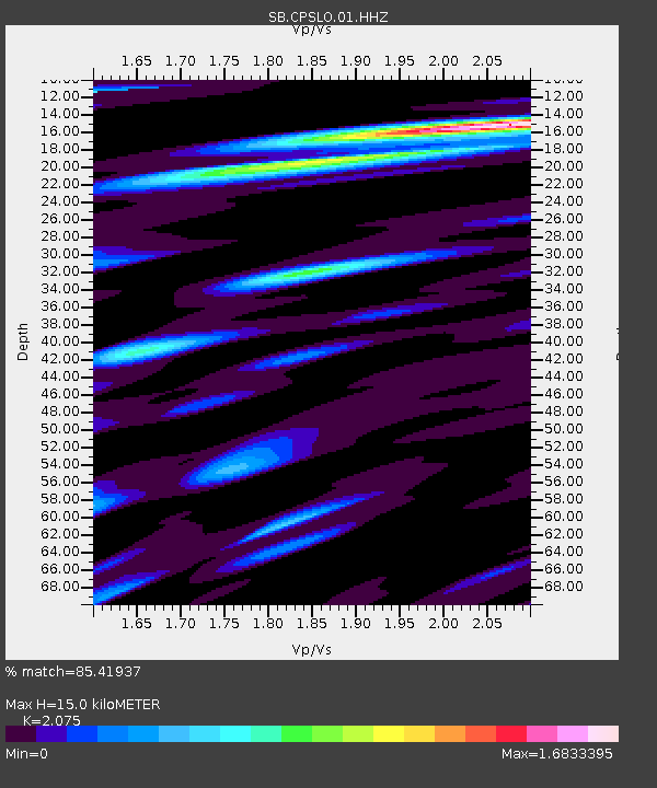
| Estimated Moho Depth: |
15.0 km |
| Estimated Crust Vp/Vs: |
2.08 |
| Assumed Crust Vp: |
6.183 km/s |
| Estimated Crust Vs: |
2.98 km/s |
| Estimated Crust Poisson's Ratio: |
0.35 |
|
| Radial Match: |
85.41937 % |
| Radial Bump: |
400 |
| Transverse Match: |
77.13145 % |
| Transverse Bump: |
400 |
| SOD ConfigId: |
34243671 |
| Insert Time: |
2024-05-02 06:42:19.064 +0000 |
| GWidth: |
2.5 |
| Max Bumps: |
400 |
| Tol: |
0.001 |
|

Signal To Noise
| Channel | StoN | STA | LTA |
| SB:CPSLO:01:HHZ:20221214T18:48:09.469986Z | 52.8223 | 1.0027464E-5 | 1.898339E-7 |
| SB:CPSLO:01:HHN:20221214T18:48:09.469986Z | 7.391175 | 2.5873915E-6 | 3.50065E-7 |
| SB:CPSLO:01:HHE:20221214T18:48:09.469986Z | 13.884199 | 5.360926E-6 | 3.8611705E-7 |
| Arrivals |
| Ps | 2.7 SECOND |
| PpPs | 7.1 SECOND |
| PsPs/PpSs | 9.8 SECOND |


