You are here: Home > Network List > XG92 - Rocky Mountain Front Stations List
> Station GUN Gunnison, CO > Earthquake Result Viewer
GUN Gunnison, CO - Earthquake Result Viewer
| Earthquake location: |
Svalbard Region |
| Earthquake latitude/longitude: |
76.2/7.2 |
| Earthquake time(UTC): |
1992/09/09 (253) 13:08:54 GMT |
| Earthquake Depth: |
24 km |
| Earthquake Magnitude: |
5.7 MB, 5.6 MS |
| Earthquake Catalog/Contributor: |
WHDF/NEIC |
|
| Network: |
XG Rocky Mountain Front |
| Station: |
GUN Gunnison, CO |
| Lat/Lon: |
38.47 N/107.06 W |
| Elevation: |
2378 m |
|
| Distance: |
58.4 deg |
| Az: |
302.867 deg |
| Baz: |
14.879 deg |
| Ray Param: |
0.06283584 |
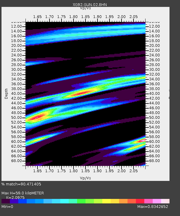
| Estimated Moho Depth: |
59.0 km |
| Estimated Crust Vp/Vs: |
2.10 |
| Assumed Crust Vp: |
6.306 km/s |
| Estimated Crust Vs: |
3.006 km/s |
| Estimated Crust Poisson's Ratio: |
0.35 |
|
| Radial Match: |
90.471405 % |
| Radial Bump: |
400 |
| Transverse Match: |
80.49926 % |
| Transverse Bump: |
400 |
| SOD ConfigId: |
3286 |
| Insert Time: |
2010-02-25 20:08:46.501 +0000 |
| GWidth: |
2.5 |
| Max Bumps: |
400 |
| Tol: |
0.001 |
|
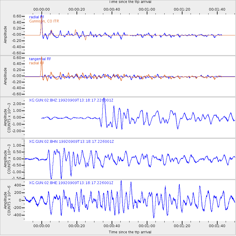
Signal To Noise
| Channel | StoN | STA | LTA |
| XG:GUN:02:BHN:19920909T13:18:17.226001Z | 7.807933 | 2.7238255E-4 | 3.488536E-5 |
| XG:GUN:02:BHE:19920909T13:18:17.226001Z | 2.6583266 | 1.0367404E-4 | 3.899974E-5 |
| XG:GUN:02:BHZ:19920909T13:18:17.226001Z | 5.5525885 | 4.8182422E-4 | 8.67747E-5 |
| Arrivals |
| Ps | 11 SECOND |
| PpPs | 28 SECOND |
| PsPs/PpSs | 39 SECOND |


