
Station XG GUN - Gunnison, CO
Network: XG92 - Rocky Mountain Front
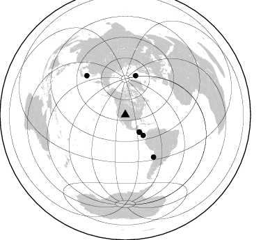
Nearby stations (2 deg radius)
| Station | Name | (Lat, Lon) | Start / End | Elevation |
| GUN | Gunnison, CO | (38.47, -107.06) | 1992-05-23 / 2499-01-01 | 2.4 km |
| Crust2 Type: | P4,orogen/50km, Urals, Tethian Orogen, Rockies 1 km seds. |
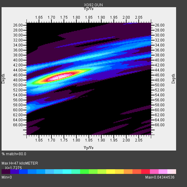
| Thickness Estimate: | 47 km |
| Thickness StdDev: | 2.8 km |
| Vp/Vs Estimate: | 1.73 |
| Vp/Vs StdDev: | 0.05 |
| Vs Estimate: | 3.65 km/s |
| Poisson's Ratio: | 0.25 |
| Peak Value: | 0.04 |
| Assumed Vp: | 6.306 km/s |
| Ps Weight: | 0.33333334 |
| PpPs Weight: | 0.33333334 |
| PsPs Weight: | 0.33333328 |
| Residual Complexity: | 0.561 |
| Nearby stations H: | +- |
| (2.0 deg) Vp/Vs: | +- |
4 with match > 90% ( 66.666664 %) and 6 with match > 80% ( 100.0 %) out of 6.
Download stack as xyz text file.
Azimuth Distribution of Events:
Prior Results for this Station
| Study | Thickness | Vp/Vs | Vp | Vs | Poissons Ratio | Extra |
| EARS | 47 km | 1.73 | 6.306 km/s | 3.65 km/s | 0.25 | |
| Crust2.0 | 50 km | 1.76 | 6.306 km/s | 3.584 km/s | 0.26 | P4,orogen/50km, Urals, Tethian Orogen, Rockies 1 km seds. |
| Global Maxima | 47 km | 1.73 | 6.306 km/s | 3.65 km/s | 0.25 | amp=0.04344536 |
| Local Maxima 1 | 45 km | 1.76 | 6.306 km/s | 3.583 km/s | 0.26 | amp=0.023733614 |
| Local Maxima 2 | 44 km | 1.61 | 6.306 km/s | 3.917 km/s | 0.19 | amp=0.014169529 |
| Local Maxima 3 | 59 km | 1.60 | 6.306 km/s | 3.941 km/s | 0.18 | amp=0.011426154 |
| Local Maxima 4 | 41 km | 1.90 | 6.306 km/s | 3.315 km/s | 0.31 | amp=0.01032565 |
| Predicted Arrivals for vertical incidence (zero ray parameter) | |
| Ps | 5.42 SECOND |
| PpPs | 20.33 SECOND |
| PsPs/PpSs | 25.75 SECOND |
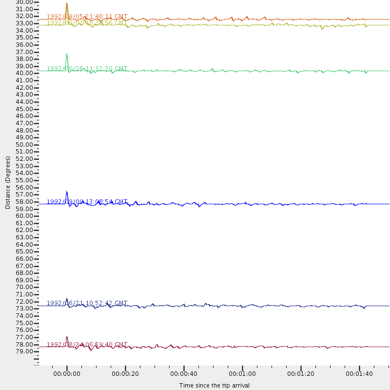
Events Processed for this Station
Download zip of receiver functions as SAC
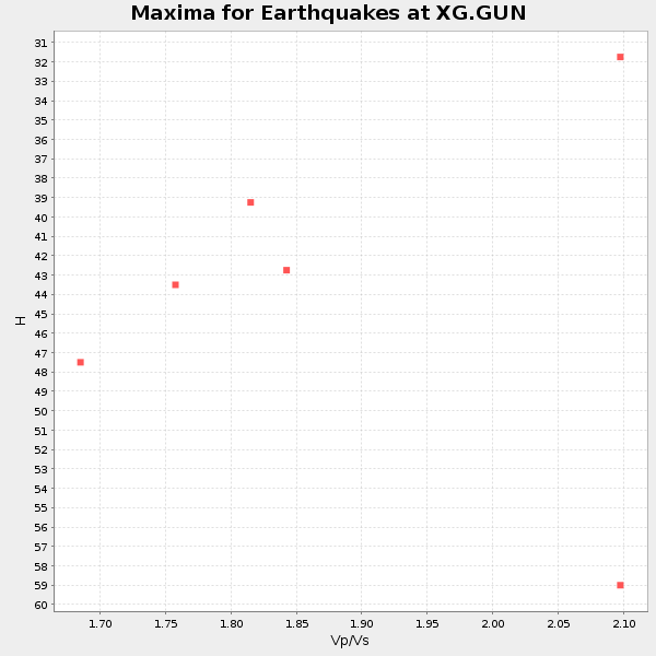
Plot maxima for each earthquake.
Events Used in the Stack
(6 events)| Radial Match | Distance | Baz | FERegion | Time | Lat/Lon | Depth | Magnitude |
| 93.56686 | 79.0 deg | 315.281 deg | Hokkaido, Japan Region | 1992/08/24 06:59:40 GMT | (41.9, 140.7) | 127 km | 6.2 MB |
| 92.199776 | 31.7 deg | 141.092 deg | Near Coast Of Nicaragua | 1992/09/05 21:48:11 GMT | (12.0, -87.3) | 10 km | 5.1 MB, 5.9 MS |
| 90.471405 | 58.4 deg | 14.879 deg | Svalbard Region | 1992/09/09 13:08:54 GMT | (76.2, 7.2) | 24 km | 5.7 MB, 5.6 MS |
| 90.38983 | 39.2 deg | 138.927 deg | South Of Panama | 1992/06/26 11:32:30 GMT | (6.1, -82.4) | 33 km | 5.8 MB, 5.4 MS |
| 85.88315 | 32.6 deg | 140.803 deg | Near Coast Of Nicaragua | 1992/09/02 18:28:56 GMT | (11.3, -86.8) | 10 km | 5.2 MB, 5.8 MS |
| 83.33255 | 73.1 deg | 146.217 deg | Near Coast Of Northern Chile | 1992/06/21 10:52:42 GMT | (-26.5, -70.6) | 39 km | 5.6 MB, 5.3 MS |
Losers
(0 events)| Radial Match | Distance | Baz | FERegion | Time | Lat/Lon | Depth | Magnitude | Reason |
