You are here: Home > Network List > XG92 - Rocky Mountain Front Stations List
> Station GUN Gunnison, CO > Earthquake Result Viewer
GUN Gunnison, CO - Earthquake Result Viewer
| Earthquake location: |
Near Coast Of Nicaragua |
| Earthquake latitude/longitude: |
12.0/-87.3 |
| Earthquake time(UTC): |
1992/09/05 (249) 21:48:11 GMT |
| Earthquake Depth: |
10 km |
| Earthquake Magnitude: |
5.1 MB, 5.9 MS |
| Earthquake Catalog/Contributor: |
WHDF/NEIC |
|
| Network: |
XG Rocky Mountain Front |
| Station: |
GUN Gunnison, CO |
| Lat/Lon: |
38.47 N/107.06 W |
| Elevation: |
2378 m |
|
| Distance: |
31.7 deg |
| Az: |
329.749 deg |
| Baz: |
141.092 deg |
| Ray Param: |
0.078962184 |
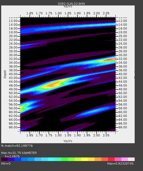
| Estimated Moho Depth: |
31.75 km |
| Estimated Crust Vp/Vs: |
2.10 |
| Assumed Crust Vp: |
6.306 km/s |
| Estimated Crust Vs: |
3.006 km/s |
| Estimated Crust Poisson's Ratio: |
0.35 |
|
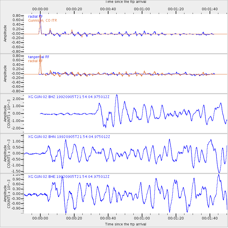
| Radial Match: |
92.199776 % |
| Radial Bump: |
210 |
| Transverse Match: |
75.7086 % |
| Transverse Bump: |
400 |
| SOD ConfigId: |
3286 |
| Insert Time: |
2010-02-25 20:08:47.829 +0000 |
| GWidth: |
2.5 |
| Max Bumps: |
400 |
| Tol: |
0.001 |
|
Signal To Noise
| Channel | StoN | STA | LTA |
| XG:GUN:02:BHN:19920905T21:54:04.975012Z | 3.038979 | 2.1812592E-4 | 7.177605E-5 |
| XG:GUN:02:BHE:19920905T21:54:04.975012Z | 2.3822575 | 1.115832E-4 | 4.6839265E-5 |
| XG:GUN:02:BHZ:19920905T21:54:04.975012Z | 8.268606 | 4.7828388E-4 | 5.784335E-5 |
| Arrivals |
| Ps | 5.9 SECOND |
| PpPs | 15 SECOND |
| PsPs/PpSs | 21 SECOND |


