You are here: Home > Network List > XG92 - Rocky Mountain Front Stations List
> Station GUN Gunnison, CO > Earthquake Result Viewer
GUN Gunnison, CO - Earthquake Result Viewer
| Earthquake location: |
Near Coast Of Nicaragua |
| Earthquake latitude/longitude: |
11.3/-86.8 |
| Earthquake time(UTC): |
1992/09/02 (246) 18:28:56 GMT |
| Earthquake Depth: |
10 km |
| Earthquake Magnitude: |
5.2 MB, 5.8 MS |
| Earthquake Catalog/Contributor: |
WHDF/NEIC |
|
| Network: |
XG Rocky Mountain Front |
| Station: |
GUN Gunnison, CO |
| Lat/Lon: |
38.47 N/107.06 W |
| Elevation: |
2378 m |
|
| Distance: |
32.6 deg |
| Az: |
329.621 deg |
| Baz: |
140.803 deg |
| Ray Param: |
0.07858651 |
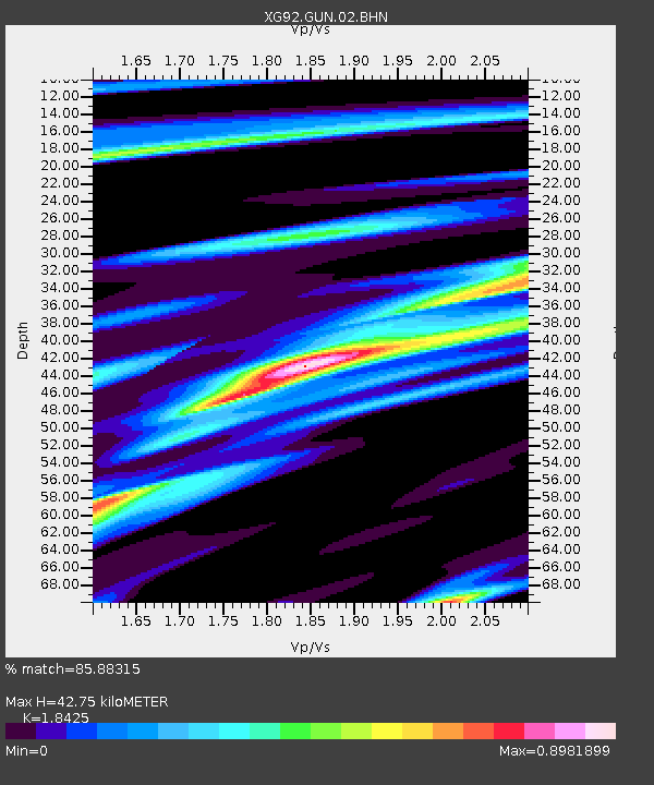
| Estimated Moho Depth: |
42.75 km |
| Estimated Crust Vp/Vs: |
1.84 |
| Assumed Crust Vp: |
6.306 km/s |
| Estimated Crust Vs: |
3.423 km/s |
| Estimated Crust Poisson's Ratio: |
0.29 |
|
| Radial Match: |
85.88315 % |
| Radial Bump: |
400 |
| Transverse Match: |
31.002544 % |
| Transverse Bump: |
400 |
| SOD ConfigId: |
3286 |
| Insert Time: |
2010-02-25 20:08:49.195 +0000 |
| GWidth: |
2.5 |
| Max Bumps: |
400 |
| Tol: |
0.001 |
|
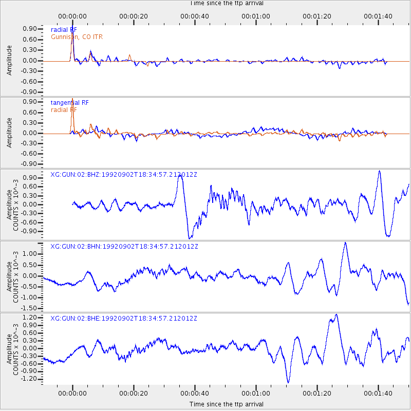
Signal To Noise
| Channel | StoN | STA | LTA |
| XG:GUN:02:BHN:19920902T18:34:57.212012Z | 1.486704 | 4.776317E-4 | 3.2126886E-4 |
| XG:GUN:02:BHE:19920902T18:34:57.212012Z | 0.5121443 | 2.2502642E-4 | 4.3938088E-4 |
| XG:GUN:02:BHZ:19920902T18:34:57.212012Z | 3.2662406 | 3.160464E-4 | 9.676152E-5 |
| Arrivals |
| Ps | 6.1 SECOND |
| PpPs | 18 SECOND |
| PsPs/PpSs | 24 SECOND |


