You are here: Home > Network List > XG92 - Rocky Mountain Front Stations List
> Station GUN Gunnison, CO > Earthquake Result Viewer
GUN Gunnison, CO - Earthquake Result Viewer
| Earthquake location: |
Hokkaido, Japan Region |
| Earthquake latitude/longitude: |
41.9/140.7 |
| Earthquake time(UTC): |
1992/08/24 (237) 06:59:40 GMT |
| Earthquake Depth: |
127 km |
| Earthquake Magnitude: |
6.2 MB |
| Earthquake Catalog/Contributor: |
WHDF/NEIC |
|
| Network: |
XG Rocky Mountain Front |
| Station: |
GUN Gunnison, CO |
| Lat/Lon: |
38.47 N/107.06 W |
| Elevation: |
2378 m |
|
| Distance: |
79.0 deg |
| Az: |
47.754 deg |
| Baz: |
315.281 deg |
| Ray Param: |
0.048972797 |
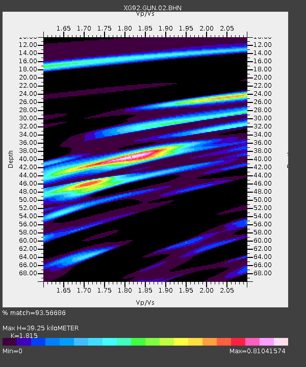
| Estimated Moho Depth: |
39.25 km |
| Estimated Crust Vp/Vs: |
1.82 |
| Assumed Crust Vp: |
6.306 km/s |
| Estimated Crust Vs: |
3.474 km/s |
| Estimated Crust Poisson's Ratio: |
0.28 |
|
| Radial Match: |
93.56686 % |
| Radial Bump: |
400 |
| Transverse Match: |
83.41492 % |
| Transverse Bump: |
400 |
| SOD ConfigId: |
3286 |
| Insert Time: |
2010-02-25 20:08:50.928 +0000 |
| GWidth: |
2.5 |
| Max Bumps: |
400 |
| Tol: |
0.001 |
|
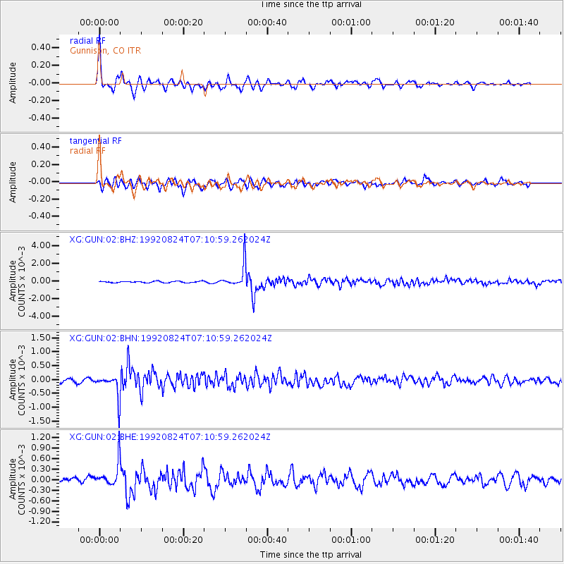
Signal To Noise
| Channel | StoN | STA | LTA |
| XG:GUN:02:BHN:19920824T07:10:59.262024Z | 7.882023 | 4.4043924E-4 | 5.5878958E-5 |
| XG:GUN:02:BHE:19920824T07:10:59.262024Z | 6.990305 | 3.589957E-4 | 5.1356226E-5 |
| XG:GUN:02:BHZ:19920824T07:10:59.262024Z | 17.585077 | 0.0013894844 | 7.9014964E-5 |
| Arrivals |
| Ps | 5.2 SECOND |
| PpPs | 17 SECOND |
| PsPs/PpSs | 22 SECOND |


