You are here: Home > Network List > XG92 - Rocky Mountain Front Stations List
> Station GUN Gunnison, CO > Earthquake Result Viewer
GUN Gunnison, CO - Earthquake Result Viewer
| Earthquake location: |
South Of Panama |
| Earthquake latitude/longitude: |
6.1/-82.4 |
| Earthquake time(UTC): |
1992/06/26 (178) 11:32:30 GMT |
| Earthquake Depth: |
33 km |
| Earthquake Magnitude: |
5.8 MB, 5.4 MS |
| Earthquake Catalog/Contributor: |
WHDF/NEIC |
|
| Network: |
XG Rocky Mountain Front |
| Station: |
GUN Gunnison, CO |
| Lat/Lon: |
38.47 N/107.06 W |
| Elevation: |
2378 m |
|
| Distance: |
39.2 deg |
| Az: |
328.759 deg |
| Baz: |
138.927 deg |
| Ray Param: |
0.07505376 |
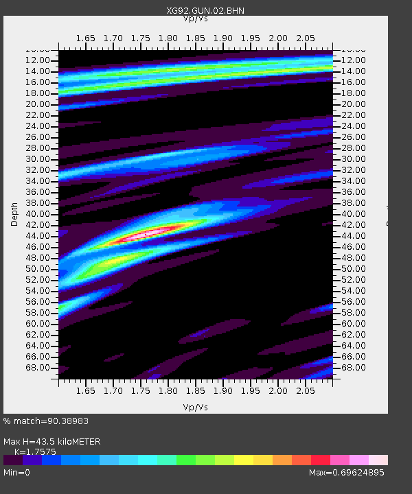
| Estimated Moho Depth: |
43.5 km |
| Estimated Crust Vp/Vs: |
1.76 |
| Assumed Crust Vp: |
6.306 km/s |
| Estimated Crust Vs: |
3.588 km/s |
| Estimated Crust Poisson's Ratio: |
0.26 |
|
| Radial Match: |
90.38983 % |
| Radial Bump: |
206 |
| Transverse Match: |
64.170235 % |
| Transverse Bump: |
400 |
| SOD ConfigId: |
3286 |
| Insert Time: |
2010-02-25 20:08:52.546 +0000 |
| GWidth: |
2.5 |
| Max Bumps: |
400 |
| Tol: |
0.001 |
|
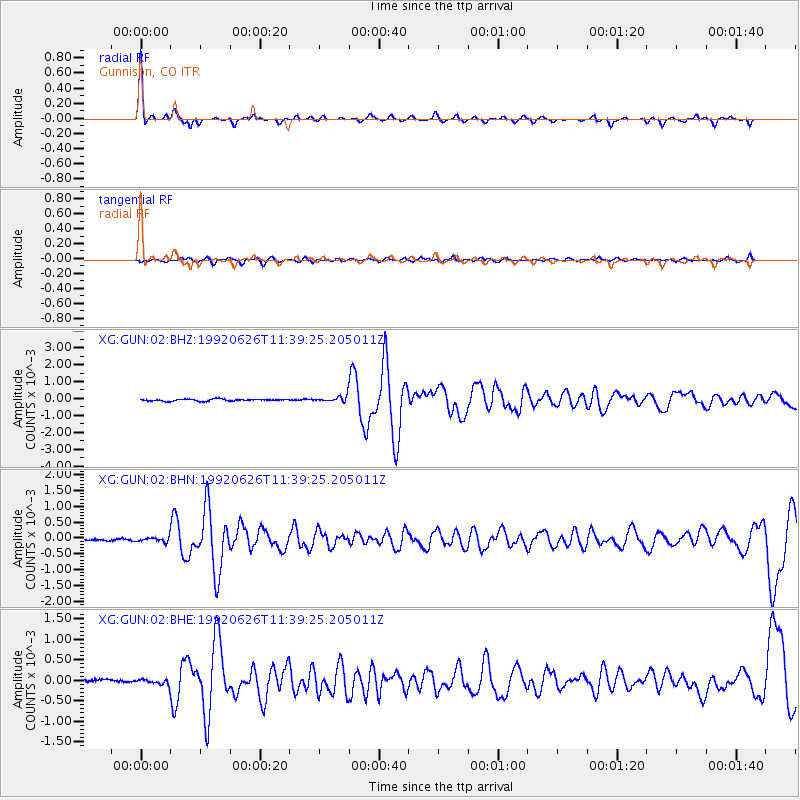
Signal To Noise
| Channel | StoN | STA | LTA |
| XG:GUN:02:BHN:19920626T11:39:25.205011Z | 2.097877 | 8.1301594E-5 | 3.8754224E-5 |
| XG:GUN:02:BHE:19920626T11:39:25.205011Z | 1.8220605 | 6.894363E-5 | 3.783828E-5 |
| XG:GUN:02:BHZ:19920626T11:39:25.205011Z | 3.0997465 | 1.6925234E-4 | 5.4602E-5 |
| Arrivals |
| Ps | 5.6 SECOND |
| PpPs | 18 SECOND |
| PsPs/PpSs | 23 SECOND |


