You are here: Home > Network List > XG92 - Rocky Mountain Front Stations List
> Station GUN Gunnison, CO > Earthquake Result Viewer
GUN Gunnison, CO - Earthquake Result Viewer
| Earthquake location: |
Near Coast Of Northern Chile |
| Earthquake latitude/longitude: |
-26.5/-70.6 |
| Earthquake time(UTC): |
1992/06/21 (173) 10:52:42 GMT |
| Earthquake Depth: |
39 km |
| Earthquake Magnitude: |
5.6 MB, 5.3 MS |
| Earthquake Catalog/Contributor: |
WHDF/NEIC |
|
| Network: |
XG Rocky Mountain Front |
| Station: |
GUN Gunnison, CO |
| Lat/Lon: |
38.47 N/107.06 W |
| Elevation: |
2378 m |
|
| Distance: |
73.1 deg |
| Az: |
330.856 deg |
| Baz: |
146.217 deg |
| Ray Param: |
0.053184964 |
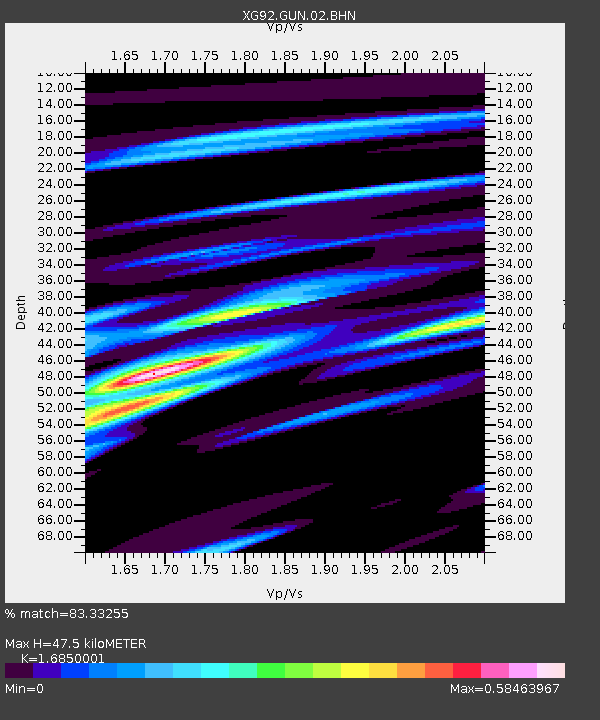
| Estimated Moho Depth: |
47.5 km |
| Estimated Crust Vp/Vs: |
1.69 |
| Assumed Crust Vp: |
6.306 km/s |
| Estimated Crust Vs: |
3.742 km/s |
| Estimated Crust Poisson's Ratio: |
0.23 |
|
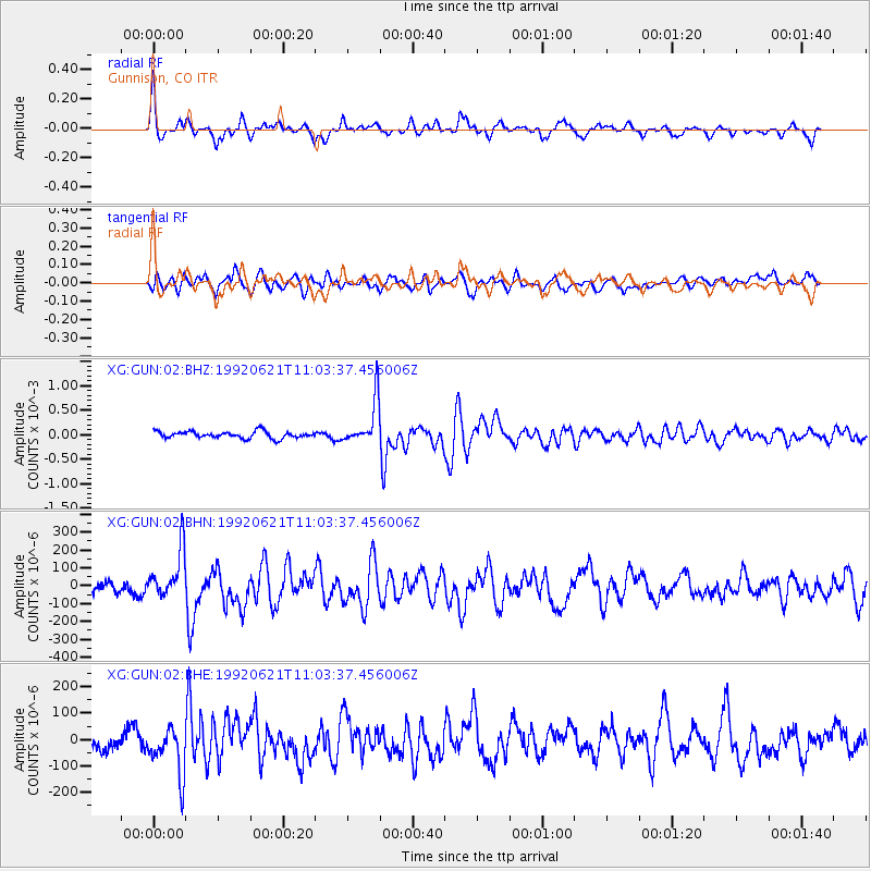
| Radial Match: |
83.33255 % |
| Radial Bump: |
400 |
| Transverse Match: |
64.29874 % |
| Transverse Bump: |
400 |
| SOD ConfigId: |
3286 |
| Insert Time: |
2010-02-25 20:08:53.649 +0000 |
| GWidth: |
2.5 |
| Max Bumps: |
400 |
| Tol: |
0.001 |
|
Signal To Noise
| Channel | StoN | STA | LTA |
| XG:GUN:02:BHN:19920621T11:03:37.456006Z | 3.1618366 | 1.3198513E-4 | 4.1743184E-5 |
| XG:GUN:02:BHE:19920621T11:03:37.456006Z | 2.2478938 | 9.07683E-5 | 4.0379266E-5 |
| XG:GUN:02:BHZ:19920621T11:03:37.456006Z | 6.595597 | 4.595352E-4 | 6.967303E-5 |
| Arrivals |
| Ps | 5.3 SECOND |
| PpPs | 20 SECOND |
| PsPs/PpSs | 25 SECOND |


