You are here: Home > Network List > XG92 - Rocky Mountain Front Stations List
> Station HLD N of I 70 on CO UT border > Earthquake Result Viewer
HLD N of I 70 on CO UT border - Earthquake Result Viewer
| Earthquake location: |
Near Coast Of Nicaragua |
| Earthquake latitude/longitude: |
11.8/-87.4 |
| Earthquake time(UTC): |
1992/09/02 (246) 00:15:57 GMT |
| Earthquake Depth: |
10 km |
| Earthquake Magnitude: |
5.3 MB, 7.2 MS |
| Earthquake Catalog/Contributor: |
WHDF/NEIC |
|
| Network: |
XG Rocky Mountain Front |
| Station: |
HLD N of I 70 on CO UT border |
| Lat/Lon: |
39.23 N/109.14 W |
| Elevation: |
1452 m |
|
| Distance: |
33.5 deg |
| Az: |
328.587 deg |
| Baz: |
138.918 deg |
| Ray Param: |
0.078192264 |
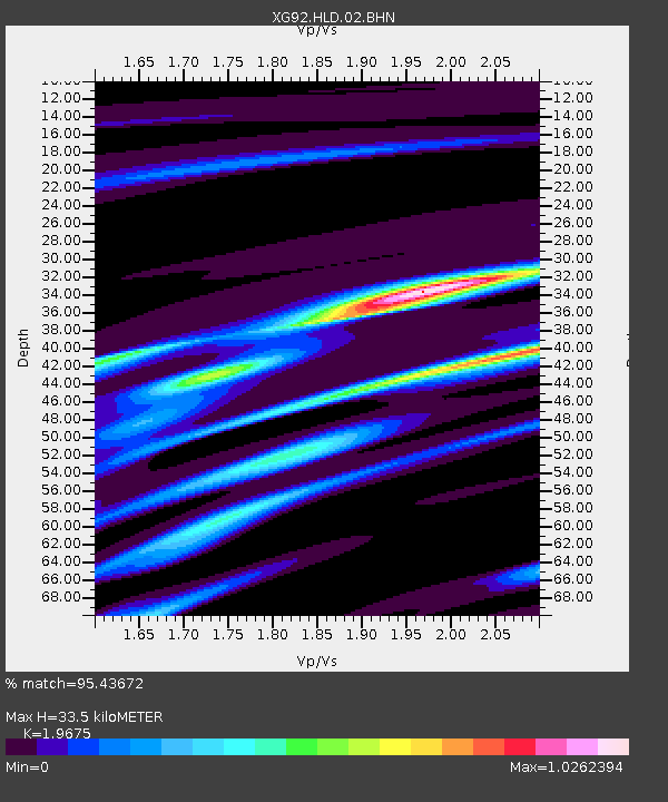
| Estimated Moho Depth: |
33.5 km |
| Estimated Crust Vp/Vs: |
1.97 |
| Assumed Crust Vp: |
6.291 km/s |
| Estimated Crust Vs: |
3.197 km/s |
| Estimated Crust Poisson's Ratio: |
0.33 |
|
| Radial Match: |
95.43672 % |
| Radial Bump: |
225 |
| Transverse Match: |
72.13918 % |
| Transverse Bump: |
400 |
| SOD ConfigId: |
3286 |
| Insert Time: |
2010-02-25 20:09:00.741 +0000 |
| GWidth: |
2.5 |
| Max Bumps: |
400 |
| Tol: |
0.001 |
|
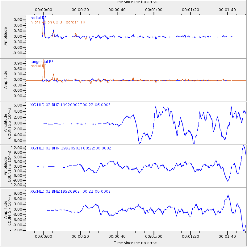
Signal To Noise
| Channel | StoN | STA | LTA |
| XG:HLD:02:BHN:19920902T00:22:06.000Z | 1.7567389 | 1.07451655E-4 | 6.116541E-5 |
| XG:HLD:02:BHE:19920902T00:22:06.000Z | 1.3934734 | 7.134013E-5 | 5.1195908E-5 |
| XG:HLD:02:BHZ:19920902T00:22:06.000Z | 3.3065488 | 1.7536484E-4 | 5.3035612E-5 |
| Arrivals |
| Ps | 5.5 SECOND |
| PpPs | 15 SECOND |
| PsPs/PpSs | 20 SECOND |


