
Station XG HLD - N of I 70 on CO UT border
Network: XG92 - Rocky Mountain Front
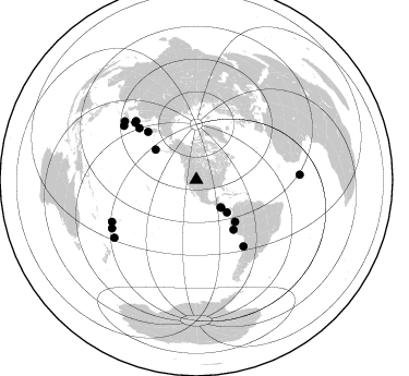
Nearby stations (2 deg radius)
| Station | Name | (Lat, Lon) | Start / End | Elevation |
| HLD | N of I 70 on CO UT border | (39.23, -109.14) | 1992-05-23 / 2499-01-01 | 1.5 km |
| Crust2 Type: | Q3,orogen/43km no ice, Appalachians, 3 km seds. |
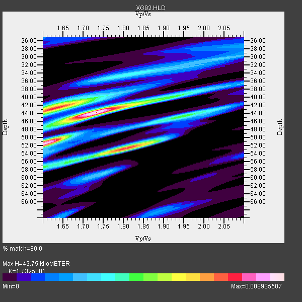
| Thickness Estimate: | 44 km |
| Thickness StdDev: | 4.8 km |
| Vp/Vs Estimate: | 1.73 |
| Vp/Vs StdDev: | 0.09 |
| Vs Estimate: | 3.631 km/s |
| Poisson's Ratio: | 0.25 |
| Peak Value: | 0.01 |
| Assumed Vp: | 6.291 km/s |
| Ps Weight: | 0.33333334 |
| PpPs Weight: | 0.33333334 |
| PsPs Weight: | 0.33333328 |
| Residual Complexity: | 0.782 |
| Nearby stations H: | +- |
| (2.0 deg) Vp/Vs: | +- |
9 with match > 90% ( 52.941177 %) and 17 with match > 80% ( 100.0 %) out of 17.
Download stack as xyz text file.
Azimuth Distribution of Events:
Prior Results for this Station
| Study | Thickness | Vp/Vs | Vp | Vs | Poissons Ratio | Extra |
| EARS | 44 km | 1.73 | 6.291 km/s | 3.631 km/s | 0.25 | |
| Crust2.0 | 43 km | 1.76 | 6.291 km/s | 3.577 km/s | 0.26 | Q3,orogen/43km no ice, Appalachians, 3 km seds. |
| Global Maxima | 44 km | 1.73 | 6.291 km/s | 3.631 km/s | 0.25 | amp=0.008935507 |
| Local Maxima 1 | 52 km | 1.60 | 6.291 km/s | 3.932 km/s | 0.18 | amp=0.007925493 |
| Local Maxima 2 | 52 km | 1.81 | 6.291 km/s | 3.48 km/s | 0.28 | amp=0.007662707 |
| Local Maxima 3 | 43 km | 1.63 | 6.291 km/s | 3.865 km/s | 0.20 | amp=0.0073816893 |
| Local Maxima 4 | 56 km | 1.66 | 6.291 km/s | 3.795 km/s | 0.21 | amp=0.0035211083 |
| Predicted Arrivals for vertical incidence (zero ray parameter) | |
| Ps | 5.09 SECOND |
| PpPs | 19.00 SECOND |
| PsPs/PpSs | 24.10 SECOND |
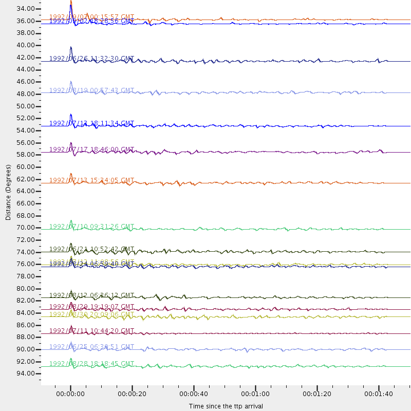
Events Processed for this Station
Download zip of receiver functions as SAC
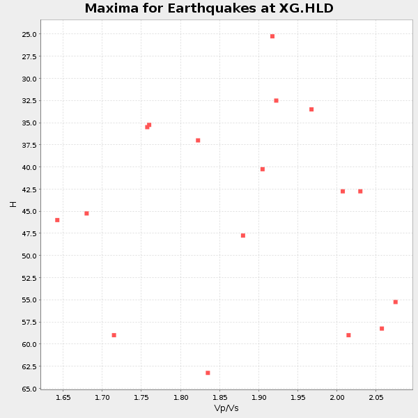
Plot maxima for each earthquake.
Events Used in the Stack
(17 events)| Radial Match | Distance | Baz | FERegion | Time | Lat/Lon | Depth | Magnitude |
| 96.685524 | 34.2 deg | 138.363 deg | Near Coast Of Nicaragua | 1992/09/02 18:28:56 GMT | (11.3, -86.8) | 10 km | 5.2 MB, 5.8 MS |
| 95.43672 | 33.5 deg | 138.918 deg | Near Coast Of Nicaragua | 1992/09/02 00:15:57 GMT | (11.8, -87.4) | 10 km | 5.3 MB, 7.2 MS |
| 94.25414 | 76.9 deg | 313.05 deg | Hokkaido, Japan Region | 1992/07/12 11:08:56 GMT | (41.4, 142.1) | 70 km | 5.9 MB |
| 93.8441 | 62.5 deg | 314.85 deg | Near East Coast Of Kamchatka | 1992/07/13 15:34:05 GMT | (51.2, 157.7) | 53 km | 5.7 MB |
| 93.63518 | 52.4 deg | 137.378 deg | Northern Peru | 1992/07/13 18:11:34 GMT | (-3.9, -76.6) | 100 km | 6.2 MB |
| 92.82086 | 84.8 deg | 309.083 deg | Southeast Of Honshu, Japan | 1992/08/29 19:19:07 GMT | (33.2, 138.0) | 309 km | 6.0 MB |
| 92.794945 | 89.1 deg | 240.101 deg | South Of Fiji Islands | 1992/07/11 10:44:20 GMT | (-22.3, -178.5) | 381 km | 6.2 MB |
| 92.36605 | 40.9 deg | 136.791 deg | South Of Panama | 1992/06/26 11:32:30 GMT | (6.1, -82.4) | 33 km | 5.8 MB, 5.4 MS |
| 91.928764 | 70.6 deg | 312.124 deg | Kuril Islands | 1992/07/10 09:31:26 GMT | (44.7, 149.5) | 11 km | 6.1 MB, 6.5 MS |
| 88.74544 | 46.5 deg | 306.566 deg | Andreanof Islands, Aleutian Is. | 1992/08/19 00:57:43 GMT | (50.5, -174.8) | 33 km | 6.1 MB, 5.7 MS, 5.6 ML |
| 87.03499 | 82.8 deg | 306.652 deg | Southeast Of Honshu, Japan | 1992/08/12 06:36:12 GMT | (32.8, 141.8) | 33 km | 5.5 MB, 5.6 MS |
| 86.81657 | 86.2 deg | 243.571 deg | Fiji Islands Region | 1992/08/30 20:09:06 GMT | (-17.7, -178.8) | 573 km | 5.8 MB |
| 83.84655 | 95.0 deg | 87.246 deg | North Of Ascension Island | 1992/08/28 18:18:45 GMT | (-1.0, -13.6) | 10 km | 6.4 MB, 7.0 MS |
| 83.37809 | 77.3 deg | 314.107 deg | Hokkaido, Japan Region | 1992/08/24 06:59:40 GMT | (41.9, 140.7) | 127 km | 6.2 MB |
| 83.08116 | 91.9 deg | 234.833 deg | Kermadec Islands Region | 1992/06/25 06:30:51 GMT | (-28.1, -176.7) | 18 km | 6.1 MB, 6.5 MS |
| 82.82183 | 57.0 deg | 143.349 deg | Near Coast Of Peru | 1992/07/17 18:46:00 GMT | (-10.4, -78.6) | 44 km | 5.5 MB, 5.4 MS |
| 80.876595 | 74.6 deg | 144.65 deg | Near Coast Of Northern Chile | 1992/06/21 10:52:42 GMT | (-26.5, -70.6) | 39 km | 5.6 MB, 5.3 MS |
Losers
(0 events)| Radial Match | Distance | Baz | FERegion | Time | Lat/Lon | Depth | Magnitude | Reason |
