You are here: Home > Network List > XG92 - Rocky Mountain Front Stations List
> Station HLD N of I 70 on CO UT border > Earthquake Result Viewer
HLD N of I 70 on CO UT border - Earthquake Result Viewer
| Earthquake location: |
Fiji Islands Region |
| Earthquake latitude/longitude: |
-17.7/-178.8 |
| Earthquake time(UTC): |
1992/08/30 (243) 20:09:06 GMT |
| Earthquake Depth: |
573 km |
| Earthquake Magnitude: |
5.8 MB |
| Earthquake Catalog/Contributor: |
WHDF/NEIC |
|
| Network: |
XG Rocky Mountain Front |
| Station: |
HLD N of I 70 on CO UT border |
| Lat/Lon: |
39.23 N/109.14 W |
| Elevation: |
1452 m |
|
| Distance: |
86.2 deg |
| Az: |
46.869 deg |
| Baz: |
243.571 deg |
| Ray Param: |
0.042601023 |
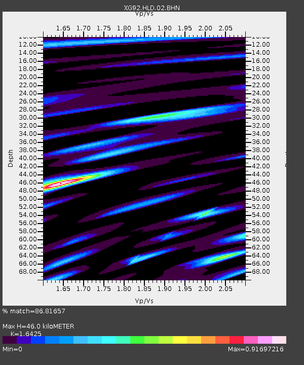
| Estimated Moho Depth: |
46.0 km |
| Estimated Crust Vp/Vs: |
1.64 |
| Assumed Crust Vp: |
6.291 km/s |
| Estimated Crust Vs: |
3.83 km/s |
| Estimated Crust Poisson's Ratio: |
0.21 |
|
| Radial Match: |
86.81657 % |
| Radial Bump: |
400 |
| Transverse Match: |
83.8145 % |
| Transverse Bump: |
400 |
| SOD ConfigId: |
3286 |
| Insert Time: |
2010-02-25 20:09:03.721 +0000 |
| GWidth: |
2.5 |
| Max Bumps: |
400 |
| Tol: |
0.001 |
|

Signal To Noise
| Channel | StoN | STA | LTA |
| XG:HLD:02:BHN:19920830T20:20:16.748022Z | 2.3129275 | 1.5509562E-4 | 6.7055975E-5 |
| XG:HLD:02:BHE:19920830T20:20:16.748022Z | 7.9162745 | 4.136073E-4 | 5.224772E-5 |
| XG:HLD:02:BHZ:19920830T20:20:16.748022Z | 19.126787 | 0.0013051138 | 6.823487E-5 |
| Arrivals |
| Ps | 4.8 SECOND |
| PpPs | 19 SECOND |
| PsPs/PpSs | 24 SECOND |


