You are here: Home > Network List > XG92 - Rocky Mountain Front Stations List
> Station HLD N of I 70 on CO UT border > Earthquake Result Viewer
HLD N of I 70 on CO UT border - Earthquake Result Viewer
| Earthquake location: |
Southeast Of Honshu, Japan |
| Earthquake latitude/longitude: |
32.8/141.8 |
| Earthquake time(UTC): |
1992/08/12 (225) 06:36:12 GMT |
| Earthquake Depth: |
33 km |
| Earthquake Magnitude: |
5.5 MB, 5.6 MS |
| Earthquake Catalog/Contributor: |
WHDF/NEIC |
|
| Network: |
XG Rocky Mountain Front |
| Station: |
HLD N of I 70 on CO UT border |
| Lat/Lon: |
39.23 N/109.14 W |
| Elevation: |
1452 m |
|
| Distance: |
82.8 deg |
| Az: |
47.717 deg |
| Baz: |
306.652 deg |
| Ray Param: |
0.04660146 |
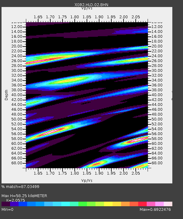
| Estimated Moho Depth: |
58.25 km |
| Estimated Crust Vp/Vs: |
2.06 |
| Assumed Crust Vp: |
6.291 km/s |
| Estimated Crust Vs: |
3.057 km/s |
| Estimated Crust Poisson's Ratio: |
0.35 |
|
| Radial Match: |
87.03499 % |
| Radial Bump: |
305 |
| Transverse Match: |
77.64889 % |
| Transverse Bump: |
400 |
| SOD ConfigId: |
3286 |
| Insert Time: |
2010-02-25 20:09:11.709 +0000 |
| GWidth: |
2.5 |
| Max Bumps: |
400 |
| Tol: |
0.001 |
|

Signal To Noise
| Channel | StoN | STA | LTA |
| XG:HLD:02:BHN:19920812T06:48:02.004004Z | 1.3588197 | 5.7571633E-5 | 4.236885E-5 |
| XG:HLD:02:BHE:19920812T06:48:02.004004Z | 0.9565097 | 4.8682115E-5 | 5.089558E-5 |
| XG:HLD:02:BHZ:19920812T06:48:02.004004Z | 4.181512 | 1.8247763E-4 | 4.3639146E-5 |
| Arrivals |
| Ps | 10 SECOND |
| PpPs | 28 SECOND |
| PsPs/PpSs | 38 SECOND |


