You are here: Home > Network List > XG92 - Rocky Mountain Front Stations List
> Station HLD N of I 70 on CO UT border > Earthquake Result Viewer
HLD N of I 70 on CO UT border - Earthquake Result Viewer
| Earthquake location: |
Near Coast Of Peru |
| Earthquake latitude/longitude: |
-10.4/-78.6 |
| Earthquake time(UTC): |
1992/07/17 (199) 18:46:00 GMT |
| Earthquake Depth: |
44 km |
| Earthquake Magnitude: |
5.5 MB, 5.4 MS |
| Earthquake Catalog/Contributor: |
WHDF/NEIC |
|
| Network: |
XG Rocky Mountain Front |
| Station: |
HLD N of I 70 on CO UT border |
| Lat/Lon: |
39.23 N/109.14 W |
| Elevation: |
1452 m |
|
| Distance: |
57.0 deg |
| Az: |
331.882 deg |
| Baz: |
143.349 deg |
| Ray Param: |
0.06368365 |
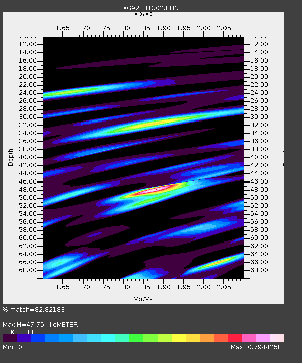
| Estimated Moho Depth: |
47.75 km |
| Estimated Crust Vp/Vs: |
1.88 |
| Assumed Crust Vp: |
6.291 km/s |
| Estimated Crust Vs: |
3.346 km/s |
| Estimated Crust Poisson's Ratio: |
0.30 |
|
| Radial Match: |
82.82183 % |
| Radial Bump: |
400 |
| Transverse Match: |
66.21818 % |
| Transverse Bump: |
400 |
| SOD ConfigId: |
3286 |
| Insert Time: |
2010-02-25 20:09:13.209 +0000 |
| GWidth: |
2.5 |
| Max Bumps: |
400 |
| Tol: |
0.001 |
|

Signal To Noise
| Channel | StoN | STA | LTA |
| XG:HLD:02:BHN:19920717T18:55:10.51001Z | 1.7474685 | 1.4033983E-4 | 8.031037E-5 |
| XG:HLD:02:BHE:19920717T18:55:10.51001Z | 1.0190581 | 9.408641E-5 | 9.232683E-5 |
| XG:HLD:02:BHZ:19920717T18:55:10.51001Z | 4.5826187 | 4.1523733E-4 | 9.061136E-5 |
| Arrivals |
| Ps | 7.0 SECOND |
| PpPs | 21 SECOND |
| PsPs/PpSs | 28 SECOND |


