You are here: Home > Network List > XG92 - Rocky Mountain Front Stations List
> Station HLD N of I 70 on CO UT border > Earthquake Result Viewer
HLD N of I 70 on CO UT border - Earthquake Result Viewer
| Earthquake location: |
Near East Coast Of Kamchatka |
| Earthquake latitude/longitude: |
51.2/157.7 |
| Earthquake time(UTC): |
1992/07/13 (195) 15:34:05 GMT |
| Earthquake Depth: |
53 km |
| Earthquake Magnitude: |
5.7 MB |
| Earthquake Catalog/Contributor: |
WHDF/NEIC |
|
| Network: |
XG Rocky Mountain Front |
| Station: |
HLD N of I 70 on CO UT border |
| Lat/Lon: |
39.23 N/109.14 W |
| Elevation: |
1452 m |
|
| Distance: |
62.5 deg |
| Az: |
60.98 deg |
| Baz: |
314.85 deg |
| Ray Param: |
0.060080323 |
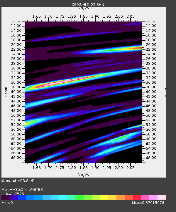
| Estimated Moho Depth: |
35.5 km |
| Estimated Crust Vp/Vs: |
1.76 |
| Assumed Crust Vp: |
6.291 km/s |
| Estimated Crust Vs: |
3.579 km/s |
| Estimated Crust Poisson's Ratio: |
0.26 |
|
| Radial Match: |
93.8441 % |
| Radial Bump: |
400 |
| Transverse Match: |
85.07321 % |
| Transverse Bump: |
400 |
| SOD ConfigId: |
3286 |
| Insert Time: |
2010-02-25 20:09:17.429 +0000 |
| GWidth: |
2.5 |
| Max Bumps: |
400 |
| Tol: |
0.001 |
|
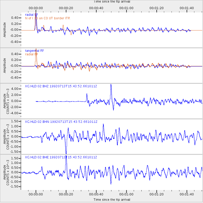
Signal To Noise
| Channel | StoN | STA | LTA |
| XG:HLD:02:BHN:19920713T15:43:52.661011Z | 3.5251791 | 1.6116434E-4 | 4.5718058E-5 |
| XG:HLD:02:BHE:19920713T15:43:52.661011Z | 5.99153 | 2.122468E-4 | 3.5424477E-5 |
| XG:HLD:02:BHZ:19920713T15:43:52.661011Z | 11.813407 | 6.623241E-4 | 5.606546E-5 |
| Arrivals |
| Ps | 4.5 SECOND |
| PpPs | 15 SECOND |
| PsPs/PpSs | 19 SECOND |


