You are here: Home > Network List > XG92 - Rocky Mountain Front Stations List
> Station HLD N of I 70 on CO UT border > Earthquake Result Viewer
HLD N of I 70 on CO UT border - Earthquake Result Viewer

| Earthquake location: |
Hokkaido, Japan Region |
| Earthquake latitude/longitude: |
41.4/142.1 |
| Earthquake time(UTC): |
1992/07/12 (194) 11:08:56 GMT |
| Earthquake Depth: |
70 km |
| Earthquake Magnitude: |
5.9 MB |
| Earthquake Catalog/Contributor: |
WHDF/NEIC |
|
| Network: |
XG Rocky Mountain Front |
| Station: |
HLD N of I 70 on CO UT border |
| Lat/Lon: |
39.23 N/109.14 W |
| Elevation: |
1452 m |
|
| Distance: |
76.9 deg |
| Az: |
49.02 deg |
| Baz: |
313.05 deg |
| Ray Param: |
0.050554205 |
| Estimated Moho Depth: |
35.25 km |
| Estimated Crust Vp/Vs: |
1.76 |
| Assumed Crust Vp: |
6.291 km/s |
| Estimated Crust Vs: |
3.574 km/s |
| Estimated Crust Poisson's Ratio: |
0.26 |
|
| Radial Match: |
94.25414 % |
| Radial Bump: |
400 |
| Transverse Match: |
87.935455 % |
| Transverse Bump: |
400 |
| SOD ConfigId: |
3286 |
| Insert Time: |
2010-02-25 20:09:19.810 +0000 |
| GWidth: |
2.5 |
| Max Bumps: |
400 |
| Tol: |
0.001 |
|
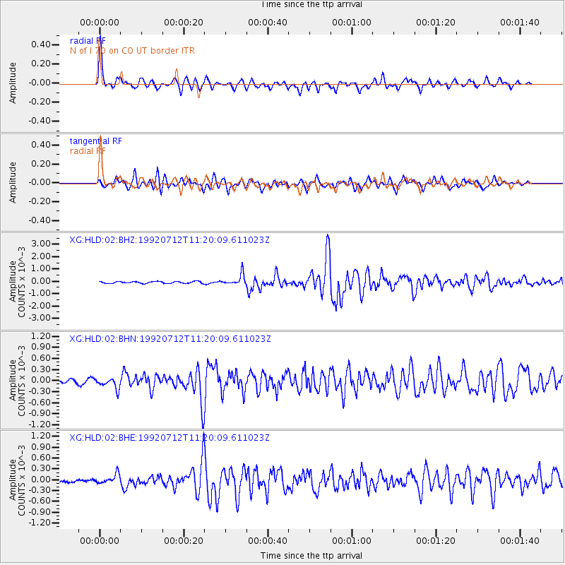
Signal To Noise
| Channel | StoN | STA | LTA |
| XG:HLD:02:BHN:19920712T11:20:09.611023Z | 3.0090153 | 1.5158433E-4 | 5.0376722E-5 |
| XG:HLD:02:BHE:19920712T11:20:09.611023Z | 3.4753501 | 1.3851092E-4 | 3.985524E-5 |
| XG:HLD:02:BHZ:19920712T11:20:09.611023Z | 6.0900297 | 4.5970277E-4 | 7.548449E-5 |
| Arrivals |
| Ps | 4.4 SECOND |
| PpPs | 15 SECOND |
| PsPs/PpSs | 19 SECOND |


