You are here: Home > Network List > XG92 - Rocky Mountain Front Stations List
> Station HLD N of I 70 on CO UT border > Earthquake Result Viewer
HLD N of I 70 on CO UT border - Earthquake Result Viewer
| Earthquake location: |
Kuril Islands |
| Earthquake latitude/longitude: |
44.7/149.5 |
| Earthquake time(UTC): |
1992/07/10 (192) 09:31:26 GMT |
| Earthquake Depth: |
11 km |
| Earthquake Magnitude: |
6.1 MB, 6.5 MS |
| Earthquake Catalog/Contributor: |
WHDF/NEIC |
|
| Network: |
XG Rocky Mountain Front |
| Station: |
HLD N of I 70 on CO UT border |
| Lat/Lon: |
39.23 N/109.14 W |
| Elevation: |
1452 m |
|
| Distance: |
70.6 deg |
| Az: |
53.834 deg |
| Baz: |
312.124 deg |
| Ray Param: |
0.054871693 |
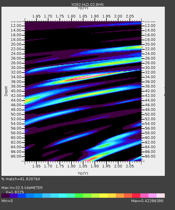
| Estimated Moho Depth: |
32.5 km |
| Estimated Crust Vp/Vs: |
1.92 |
| Assumed Crust Vp: |
6.291 km/s |
| Estimated Crust Vs: |
3.272 km/s |
| Estimated Crust Poisson's Ratio: |
0.31 |
|
| Radial Match: |
91.928764 % |
| Radial Bump: |
400 |
| Transverse Match: |
72.301956 % |
| Transverse Bump: |
400 |
| SOD ConfigId: |
3286 |
| Insert Time: |
2010-02-25 20:09:23.200 +0000 |
| GWidth: |
2.5 |
| Max Bumps: |
400 |
| Tol: |
0.001 |
|

Signal To Noise
| Channel | StoN | STA | LTA |
| XG:HLD:02:BHN:19920710T09:42:09.960022Z | 1.3838937 | 1.1104295E-4 | 8.0239515E-5 |
| XG:HLD:02:BHE:19920710T09:42:09.960022Z | 1.6459155 | 1.15410694E-4 | 7.011945E-5 |
| XG:HLD:02:BHZ:19920710T09:42:09.960022Z | 5.729052 | 3.6990756E-4 | 6.456697E-5 |
| Arrivals |
| Ps | 4.9 SECOND |
| PpPs | 15 SECOND |
| PsPs/PpSs | 20 SECOND |


