You are here: Home > Network List > XG92 - Rocky Mountain Front Stations List
> Station HLD N of I 70 on CO UT border > Earthquake Result Viewer
HLD N of I 70 on CO UT border - Earthquake Result Viewer
| Earthquake location: |
South Of Panama |
| Earthquake latitude/longitude: |
6.1/-82.4 |
| Earthquake time(UTC): |
1992/06/26 (178) 11:32:30 GMT |
| Earthquake Depth: |
33 km |
| Earthquake Magnitude: |
5.8 MB, 5.4 MS |
| Earthquake Catalog/Contributor: |
WHDF/NEIC |
|
| Network: |
XG Rocky Mountain Front |
| Station: |
HLD N of I 70 on CO UT border |
| Lat/Lon: |
39.23 N/109.14 W |
| Elevation: |
1452 m |
|
| Distance: |
40.9 deg |
| Az: |
327.67 deg |
| Baz: |
136.791 deg |
| Ray Param: |
0.074085936 |
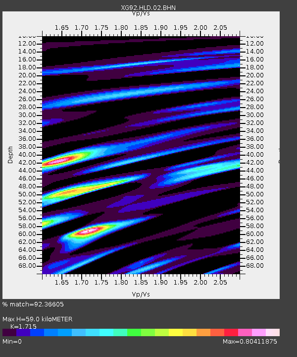
| Estimated Moho Depth: |
59.0 km |
| Estimated Crust Vp/Vs: |
1.72 |
| Assumed Crust Vp: |
6.291 km/s |
| Estimated Crust Vs: |
3.668 km/s |
| Estimated Crust Poisson's Ratio: |
0.24 |
|
| Radial Match: |
92.36605 % |
| Radial Bump: |
400 |
| Transverse Match: |
82.38499 % |
| Transverse Bump: |
400 |
| SOD ConfigId: |
3286 |
| Insert Time: |
2010-02-25 20:09:24.421 +0000 |
| GWidth: |
2.5 |
| Max Bumps: |
400 |
| Tol: |
0.001 |
|
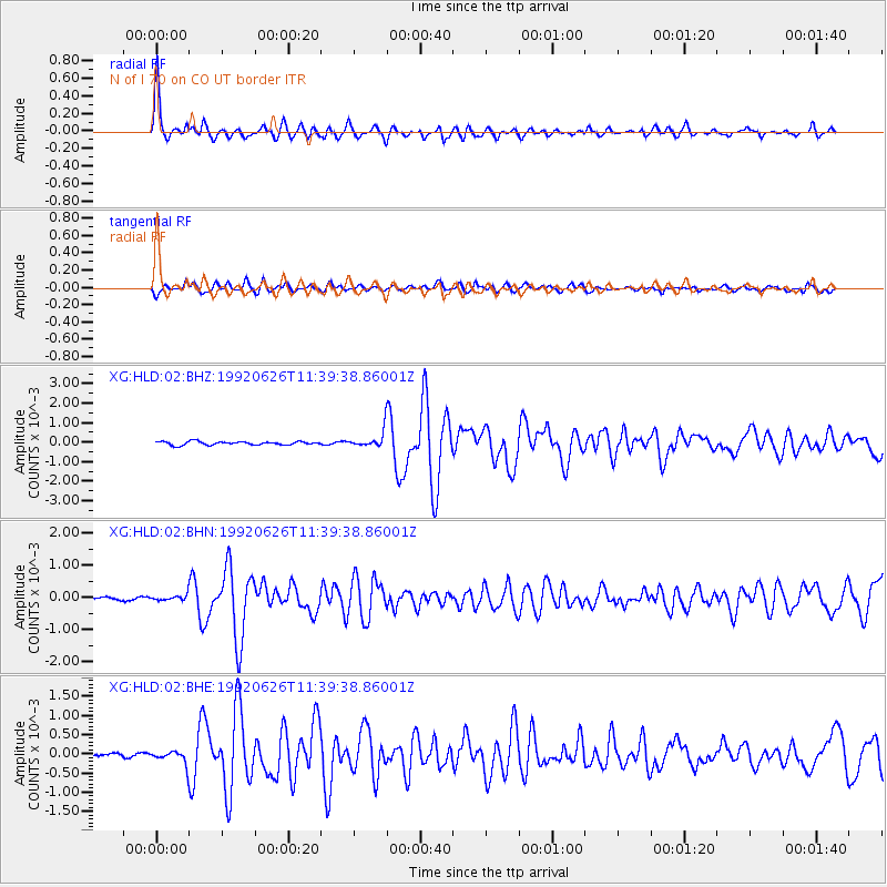
Signal To Noise
| Channel | StoN | STA | LTA |
| XG:HLD:02:BHN:19920626T11:39:38.86001Z | 1.6585858 | 9.387735E-5 | 5.660084E-5 |
| XG:HLD:02:BHE:19920626T11:39:38.86001Z | 6.3314075 | 1.8641444E-4 | 2.9442812E-5 |
| XG:HLD:02:BHZ:19920626T11:39:38.86001Z | 4.735832 | 4.1912255E-4 | 8.85003E-5 |
| Arrivals |
| Ps | 7.2 SECOND |
| PpPs | 24 SECOND |
| PsPs/PpSs | 31 SECOND |


