You are here: Home > Network List > XG92 - Rocky Mountain Front Stations List
> Station HLD N of I 70 on CO UT border > Earthquake Result Viewer
HLD N of I 70 on CO UT border - Earthquake Result Viewer
| Earthquake location: |
Kermadec Islands Region |
| Earthquake latitude/longitude: |
-28.1/-176.7 |
| Earthquake time(UTC): |
1992/06/25 (177) 06:30:51 GMT |
| Earthquake Depth: |
18 km |
| Earthquake Magnitude: |
6.1 MB, 6.5 MS |
| Earthquake Catalog/Contributor: |
WHDF/NEIC |
|
| Network: |
XG Rocky Mountain Front |
| Station: |
HLD N of I 70 on CO UT border |
| Lat/Lon: |
39.23 N/109.14 W |
| Elevation: |
1452 m |
|
| Distance: |
91.9 deg |
| Az: |
45.928 deg |
| Baz: |
234.833 deg |
| Ray Param: |
0.041537106 |
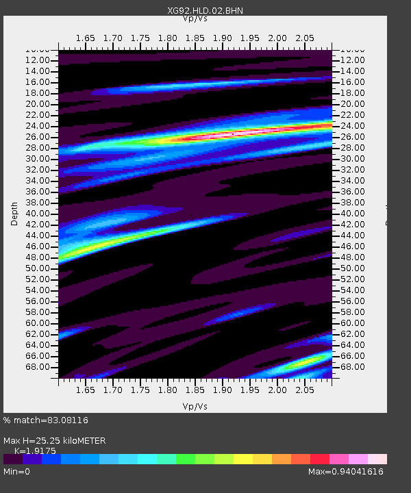
| Estimated Moho Depth: |
25.25 km |
| Estimated Crust Vp/Vs: |
1.92 |
| Assumed Crust Vp: |
6.291 km/s |
| Estimated Crust Vs: |
3.281 km/s |
| Estimated Crust Poisson's Ratio: |
0.31 |
|
| Radial Match: |
83.08116 % |
| Radial Bump: |
400 |
| Transverse Match: |
75.32645 % |
| Transverse Bump: |
400 |
| SOD ConfigId: |
3286 |
| Insert Time: |
2010-02-25 20:09:25.623 +0000 |
| GWidth: |
2.5 |
| Max Bumps: |
400 |
| Tol: |
0.001 |
|

Signal To Noise
| Channel | StoN | STA | LTA |
| XG:HLD:02:BHN:19920625T06:43:26.759021Z | 2.1499627 | 7.9270445E-5 | 3.6870613E-5 |
| XG:HLD:02:BHE:19920625T06:43:26.759021Z | 0.8198961 | 6.176346E-5 | 7.5330834E-5 |
| XG:HLD:02:BHZ:19920625T06:43:26.759021Z | 1.661572 | 9.3725255E-5 | 5.6407578E-5 |
| Arrivals |
| Ps | 3.8 SECOND |
| PpPs | 11 SECOND |
| PsPs/PpSs | 15 SECOND |


