You are here: Home > Network List > XG92 - Rocky Mountain Front Stations List
> Station HLD N of I 70 on CO UT border > Earthquake Result Viewer
HLD N of I 70 on CO UT border - Earthquake Result Viewer

| Earthquake location: |
Near Coast Of Northern Chile |
| Earthquake latitude/longitude: |
-26.5/-70.6 |
| Earthquake time(UTC): |
1992/06/21 (173) 10:52:42 GMT |
| Earthquake Depth: |
39 km |
| Earthquake Magnitude: |
5.6 MB, 5.3 MS |
| Earthquake Catalog/Contributor: |
WHDF/NEIC |
|
| Network: |
XG Rocky Mountain Front |
| Station: |
HLD N of I 70 on CO UT border |
| Lat/Lon: |
39.23 N/109.14 W |
| Elevation: |
1452 m |
|
| Distance: |
74.6 deg |
| Az: |
329.906 deg |
| Baz: |
144.65 deg |
| Ray Param: |
0.05215434 |
| Estimated Moho Depth: |
37.0 km |
| Estimated Crust Vp/Vs: |
1.82 |
| Assumed Crust Vp: |
6.291 km/s |
| Estimated Crust Vs: |
3.452 km/s |
| Estimated Crust Poisson's Ratio: |
0.28 |
|
| Radial Match: |
80.876595 % |
| Radial Bump: |
400 |
| Transverse Match: |
75.924934 % |
| Transverse Bump: |
400 |
| SOD ConfigId: |
3286 |
| Insert Time: |
2010-02-25 20:09:26.700 +0000 |
| GWidth: |
2.5 |
| Max Bumps: |
400 |
| Tol: |
0.001 |
|
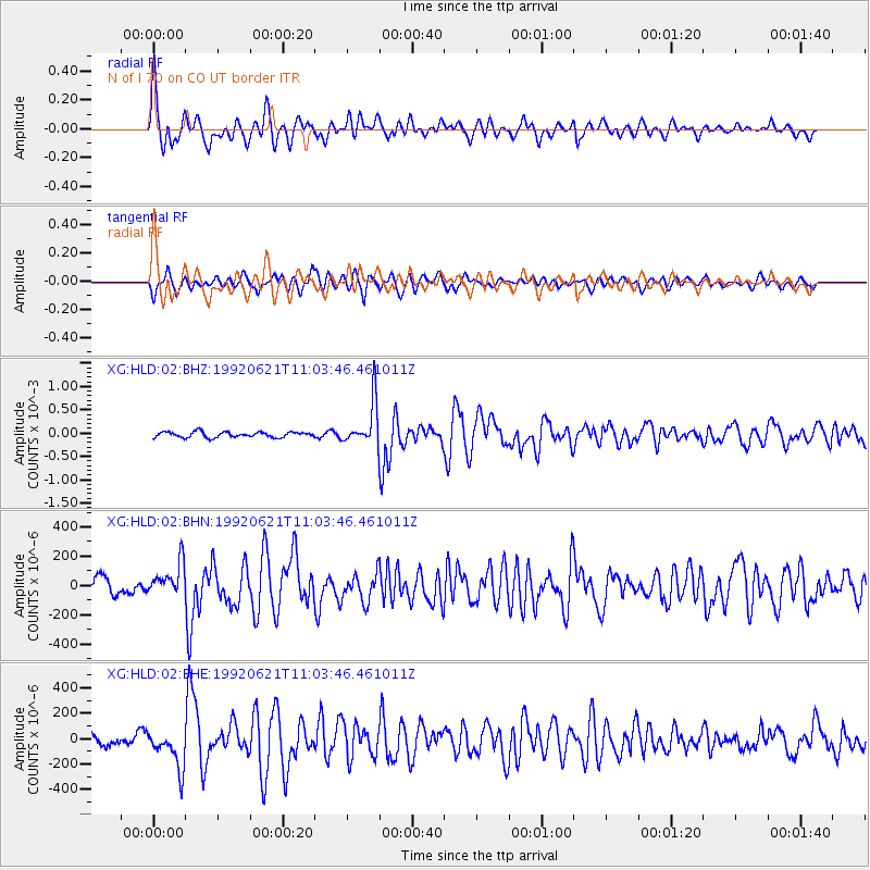
Signal To Noise
| Channel | StoN | STA | LTA |
| XG:HLD:02:BHN:19920621T11:03:46.461011Z | 1.9601741 | 1.1321067E-4 | 5.7755413E-5 |
| XG:HLD:02:BHE:19920621T11:03:46.461011Z | 2.9141815 | 1.5237511E-4 | 5.228745E-5 |
| XG:HLD:02:BHZ:19920621T11:03:46.461011Z | 8.052519 | 4.6257023E-4 | 5.744417E-5 |
| Arrivals |
| Ps | 5.0 SECOND |
| PpPs | 16 SECOND |
| PsPs/PpSs | 21 SECOND |


