You are here: Home > Network List > IC - New China Digital Seismograph Network Stations List
> Station HIA Hailar, Neimenggu Autonomous Region, China > Earthquake Result Viewer
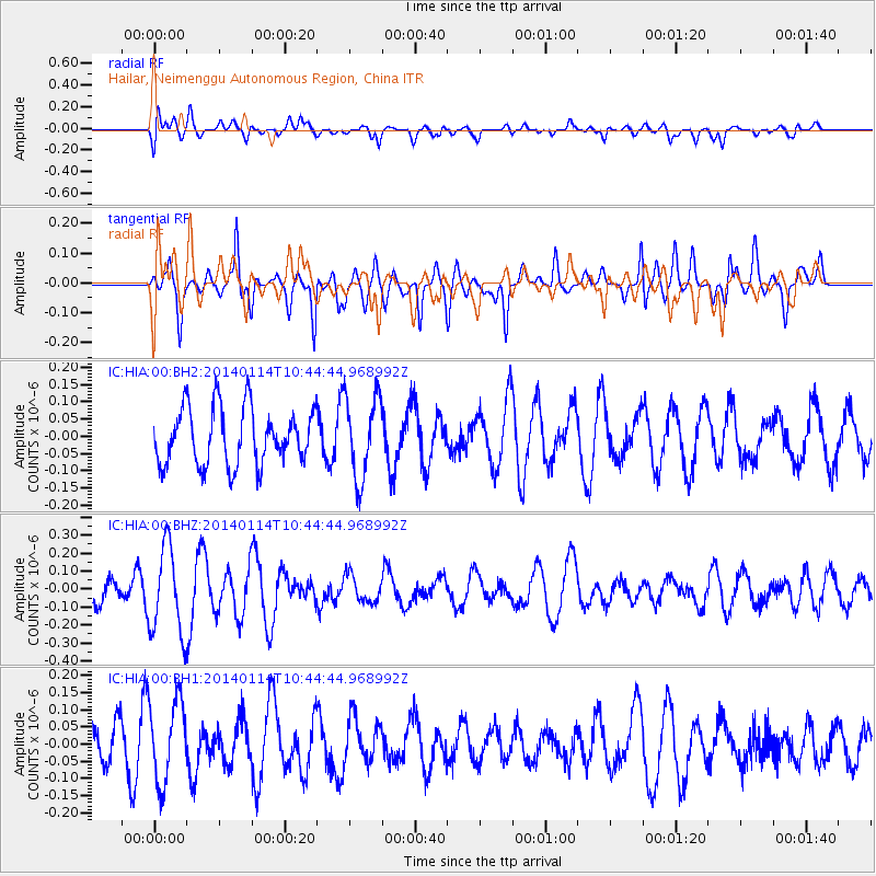
HIA Hailar, Neimenggu Autonomous Region, China - Earthquake Result Viewer
*The percent match for this event was below the threshold and hence no stack was calculated.
| Earthquake location: |
Off W Coast Of Northern Sumatra |
| Earthquake latitude/longitude: |
2.2/93.7 |
| Earthquake time(UTC): |
2014/01/14 (014) 10:36:10 GMT |
| Earthquake Depth: |
35 km |
| Earthquake Magnitude: |
4.7 mb |
| Earthquake Catalog/Contributor: |
ISC/ISC |
|
| Network: |
IC New China Digital Seismograph Network |
| Station: |
HIA Hailar, Neimenggu Autonomous Region, China |
| Lat/Lon: |
49.27 N/119.74 E |
| Elevation: |
620 m |
|
| Distance: |
51.9 deg |
| Az: |
21.411 deg |
| Baz: |
213.842 deg |
| Ray Param: |
$rayparam |
*The percent match for this event was below the threshold and hence was not used in the summary stack. |
|
| Radial Match: |
49.17837 % |
| Radial Bump: |
400 |
| Transverse Match: |
57.370968 % |
| Transverse Bump: |
400 |
| SOD ConfigId: |
3390531 |
| Insert Time: |
2019-04-09 23:56:05.794 +0000 |
| GWidth: |
2.5 |
| Max Bumps: |
400 |
| Tol: |
0.001 |
|
Signal To Noise
| Channel | StoN | STA | LTA |
| IC:HIA:00:BHZ:20140114T10:44:44.968992Z | 2.754964 | 2.4348606E-7 | 8.838085E-8 |
| IC:HIA:00:BH1:20140114T10:44:44.968992Z | 1.926434 | 1.1939399E-7 | 6.197668E-8 |
| IC:HIA:00:BH2:20140114T10:44:44.968992Z | 1.4659737 | 1.1956558E-7 | 8.156052E-8 |
| Arrivals |
| Ps | |
| PpPs | |
| PsPs/PpSs | |


