You are here: Home > Network List > XG92 - Rocky Mountain Front Stations List
> Station LED Leadville, CO > Earthquake Result Viewer
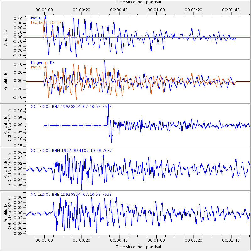
LED Leadville, CO - Earthquake Result Viewer

| Earthquake location: |
Hokkaido, Japan Region |
| Earthquake latitude/longitude: |
41.9/140.7 |
| Earthquake time(UTC): |
1992/08/24 (237) 06:59:40 GMT |
| Earthquake Depth: |
127 km |
| Earthquake Magnitude: |
6.2 MB |
| Earthquake Catalog/Contributor: |
WHDF/NEIC |
|
| Network: |
XG Rocky Mountain Front |
| Station: |
LED Leadville, CO |
| Lat/Lon: |
39.15 N/106.35 W |
| Elevation: |
2879 m |
|
| Distance: |
78.9 deg |
| Az: |
46.866 deg |
| Baz: |
315.555 deg |
| Ray Param: |
0.049036086 |
| Estimated Moho Depth: |
37.5 km |
| Estimated Crust Vp/Vs: |
1.72 |
| Assumed Crust Vp: |
6.306 km/s |
| Estimated Crust Vs: |
3.672 km/s |
| Estimated Crust Poisson's Ratio: |
0.24 |
|
| Radial Match: |
85.618385 % |
| Radial Bump: |
400 |
| Transverse Match: |
84.4928 % |
| Transverse Bump: |
400 |
| SOD ConfigId: |
3286 |
| Insert Time: |
2010-02-25 20:09:39.972 +0000 |
| GWidth: |
2.5 |
| Max Bumps: |
400 |
| Tol: |
0.001 |
|
Signal To Noise
| Channel | StoN | STA | LTA |
| XG:LED:02:BHN:19920824T07:10:58.763Z | 2.5437877 | 8.240975E-9 | 3.2396472E-9 |
| XG:LED:02:BHE:19920824T07:10:58.763Z | 2.0561295 | 9.7394395E-9 | 4.736783E-9 |
| XG:LED:02:BHZ:19920824T07:10:58.763Z | 23.458382 | 3.836349E-8 | 1.6353852E-9 |
| Arrivals |
| Ps | 4.4 SECOND |
| PpPs | 16 SECOND |
| PsPs/PpSs | 20 SECOND |


