
Station XG LED - Leadville, CO
Network: XG92 - Rocky Mountain Front
Nearby stations (2 deg radius)
| Station | Name | (Lat, Lon) | Start / End | Elevation |
| LED | Leadville, CO | (39.15, -106.35) | 1992-05-23 / 2499-01-01 | 2.9 km |
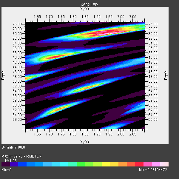
| Crust2 Type: | P4,orogen/50km, Urals, Tethian Orogen, Rockies 1 km seds. |
| Thickness Estimate: | 30 km |
| Thickness StdDev: | 12 km |
| Vp/Vs Estimate: | 1.95 |
| Vp/Vs StdDev: | 0.09 |
| Vs Estimate: | 3.234 km/s |
| Poisson's Ratio: | 0.32 |
| Peak Value: | 0.07 |
| Assumed Vp: | 6.306 km/s |
| Ps Weight: | 0.33333334 |
| PpPs Weight: | 0.33333334 |
| PsPs Weight: | 0.33333328 |
| Residual Complexity: | 0.729 |
| Nearby stations H: | +- |
| (2.0 deg) Vp/Vs: | +- |
1 with match > 90% ( 20.0 %) and 5 with match > 80% ( 100.0 %) out of 5.
Download stack as xyz text file.
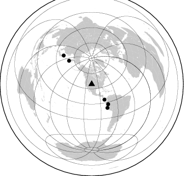
Azimuth Distribution of Events:
Prior Results for this Station
| Study | Thickness | Vp/Vs | Vp | Vs | Poissons Ratio | Extra |
| EARS | 30 km | 1.95 | 6.306 km/s | 3.234 km/s | 0.32 | |
| Crust2.0 | 50 km | 1.76 | 6.306 km/s | 3.584 km/s | 0.26 | P4,orogen/50km, Urals, Tethian Orogen, Rockies 1 km seds. |
| Global Maxima | 30 km | 1.95 | 6.306 km/s | 3.234 km/s | 0.32 | amp=0.07194472 |
| Local Maxima 1 | 40 km | 1.73 | 6.306 km/s | 3.645 km/s | 0.25 | amp=0.058673754 |
| Local Maxima 2 | 62 km | 1.74 | 6.306 km/s | 3.624 km/s | 0.25 | amp=0.054908667 |
| Local Maxima 3 | 52 km | 1.87 | 6.306 km/s | 3.377 km/s | 0.30 | amp=0.045703426 |
| Local Maxima 4 | 29 km | 1.89 | 6.306 km/s | 3.332 km/s | 0.31 | amp=0.043917786 |
| Predicted Arrivals for vertical incidence (zero ray parameter) | |
| Ps | 4.48 SECOND |
| PpPs | 13.92 SECOND |
| PsPs/PpSs | 18.40 SECOND |
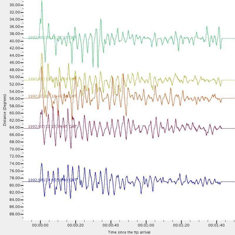
Events Processed for this Station
Download zip of receiver functions as SAC
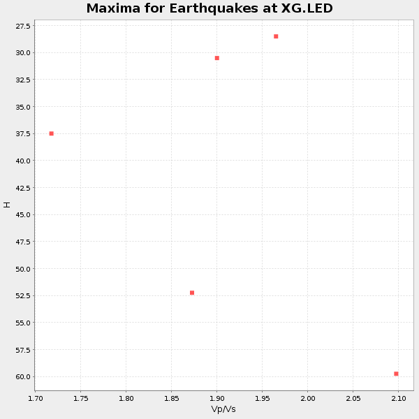
Plot maxima for each earthquake.
Events Used in the Stack
(5 events)| Radial Match | Distance | Baz | FERegion | Time | Lat/Lon | Depth | Magnitude |
| 90.8018 | 50.9 deg | 140.394 deg | Northern Peru | 1992/07/13 18:11:34 GMT | (-3.9, -76.6) | 100 km | 6.2 MB |
| 87.68517 | 39.4 deg | 140.425 deg | South Of Panama | 1992/06/26 11:32:30 GMT | (6.1, -82.4) | 33 km | 5.8 MB, 5.4 MS |
| 85.618385 | 78.9 deg | 315.555 deg | Hokkaido, Japan Region | 1992/08/24 06:59:40 GMT | (41.9, 140.7) | 127 km | 6.2 MB |
| 85.172066 | 64.1 deg | 315.858 deg | Near East Coast Of Kamchatka | 1992/07/13 15:34:05 GMT | (51.2, 157.7) | 53 km | 5.7 MB |
| 83.08248 | 55.7 deg | 146.262 deg | Near Coast Of Peru | 1992/07/17 18:46:00 GMT | (-10.4, -78.6) | 44 km | 5.5 MB, 5.4 MS |
Losers
(0 events)| Radial Match | Distance | Baz | FERegion | Time | Lat/Lon | Depth | Magnitude | Reason |
