You are here: Home > Network List > XG92 - Rocky Mountain Front Stations List
> Station LED Leadville, CO > Earthquake Result Viewer
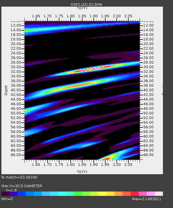
LED Leadville, CO - Earthquake Result Viewer
| Earthquake location: |
Near Coast Of Peru |
| Earthquake latitude/longitude: |
-10.4/-78.6 |
| Earthquake time(UTC): |
1992/07/17 (199) 18:46:00 GMT |
| Earthquake Depth: |
44 km |
| Earthquake Magnitude: |
5.5 MB, 5.4 MS |
| Earthquake Catalog/Contributor: |
WHDF/NEIC |
|
| Network: |
XG Rocky Mountain Front |
| Station: |
LED Leadville, CO |
| Lat/Lon: |
39.15 N/106.35 W |
| Elevation: |
2879 m |
|
| Distance: |
55.7 deg |
| Az: |
333.962 deg |
| Baz: |
146.262 deg |
| Ray Param: |
0.06454097 |
| Estimated Moho Depth: |
30.5 km |
| Estimated Crust Vp/Vs: |
1.90 |
| Assumed Crust Vp: |
6.306 km/s |
| Estimated Crust Vs: |
3.319 km/s |
| Estimated Crust Poisson's Ratio: |
0.31 |
|
| Radial Match: |
83.08248 % |
| Radial Bump: |
400 |
| Transverse Match: |
79.89939 % |
| Transverse Bump: |
400 |
| SOD ConfigId: |
3286 |
| Insert Time: |
2010-02-25 20:09:42.578 +0000 |
| GWidth: |
2.5 |
| Max Bumps: |
400 |
| Tol: |
0.001 |
|

Signal To Noise
| Channel | StoN | STA | LTA |
| XG:LED:02:BHN:19920717T18:55:01.176025Z | 1.3577567 | 3.692778E-4 | 2.7197643E-4 |
| XG:LED:02:BHE:19920717T18:55:01.176025Z | 1.098364 | 4.5586462E-4 | 4.1503966E-4 |
| XG:LED:02:BHZ:19920717T18:55:01.176025Z | 2.8944767 | 5.078756E-4 | 1.7546369E-4 |
| Arrivals |
| Ps | 4.6 SECOND |
| PpPs | 13 SECOND |
| PsPs/PpSs | 18 SECOND |


