You are here: Home > Network List > XG92 - Rocky Mountain Front Stations List
> Station LED Leadville, CO > Earthquake Result Viewer
LED Leadville, CO - Earthquake Result Viewer
| Earthquake location: |
Northern Peru |
| Earthquake latitude/longitude: |
-3.9/-76.6 |
| Earthquake time(UTC): |
1992/07/13 (195) 18:11:34 GMT |
| Earthquake Depth: |
100 km |
| Earthquake Magnitude: |
6.2 MB |
| Earthquake Catalog/Contributor: |
WHDF/NEIC |
|
| Network: |
XG Rocky Mountain Front |
| Station: |
LED Leadville, CO |
| Lat/Lon: |
39.15 N/106.35 W |
| Elevation: |
2879 m |
|
| Distance: |
50.9 deg |
| Az: |
330.21 deg |
| Baz: |
140.394 deg |
| Ray Param: |
0.06745611 |
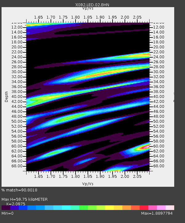
| Estimated Moho Depth: |
59.75 km |
| Estimated Crust Vp/Vs: |
2.10 |
| Assumed Crust Vp: |
6.306 km/s |
| Estimated Crust Vs: |
3.006 km/s |
| Estimated Crust Poisson's Ratio: |
0.35 |
|
| Radial Match: |
90.8018 % |
| Radial Bump: |
400 |
| Transverse Match: |
91.185814 % |
| Transverse Bump: |
400 |
| SOD ConfigId: |
3286 |
| Insert Time: |
2010-02-25 20:09:43.674 +0000 |
| GWidth: |
2.5 |
| Max Bumps: |
400 |
| Tol: |
0.001 |
|

Signal To Noise
| Channel | StoN | STA | LTA |
| XG:LED:02:BHN:19920713T18:19:54.187012Z | 6.251554 | 9.828508E-4 | 1.5721704E-4 |
| XG:LED:02:BHE:19920713T18:19:54.187012Z | 5.6248965 | 0.0010527129 | 1.8715241E-4 |
| XG:LED:02:BHZ:19920713T18:19:54.187012Z | 30.283468 | 0.0033466443 | 1.10510606E-4 |
| Arrivals |
| Ps | 11 SECOND |
| PpPs | 28 SECOND |
| PsPs/PpSs | 39 SECOND |


