You are here: Home > Network List > IC - New China Digital Seismograph Network Stations List
> Station HIA Hailar, Neimenggu Province, China > Earthquake Result Viewer
HIA Hailar, Neimenggu Province, China - Earthquake Result Viewer

| Earthquake location: |
Loyalty Islands |
| Earthquake latitude/longitude: |
-20.6/168.5 |
| Earthquake time(UTC): |
2011/01/13 (013) 16:16:41 GMT |
| Earthquake Depth: |
9.0 km |
| Earthquake Magnitude: |
6.6 MB, 7.1 MS, 7.0 MW, 6.9 MW |
| Earthquake Catalog/Contributor: |
WHDF/NEIC |
|
| Network: |
IC New China Digital Seismograph Network |
| Station: |
HIA Hailar, Neimenggu Province, China |
| Lat/Lon: |
49.27 N/119.74 E |
| Elevation: |
620 m |
|
| Distance: |
81.9 deg |
| Az: |
330.185 deg |
| Baz: |
134.683 deg |
| Ray Param: |
0.047228824 |
| Estimated Moho Depth: |
39.25 km |
| Estimated Crust Vp/Vs: |
1.64 |
| Assumed Crust Vp: |
6.577 km/s |
| Estimated Crust Vs: |
3.998 km/s |
| Estimated Crust Poisson's Ratio: |
0.21 |
|
| Radial Match: |
97.635796 % |
| Radial Bump: |
286 |
| Transverse Match: |
88.08726 % |
| Transverse Bump: |
400 |
| SOD ConfigId: |
346946 |
| Insert Time: |
2011-07-09 10:50:24.310 +0000 |
| GWidth: |
2.5 |
| Max Bumps: |
400 |
| Tol: |
0.001 |
|
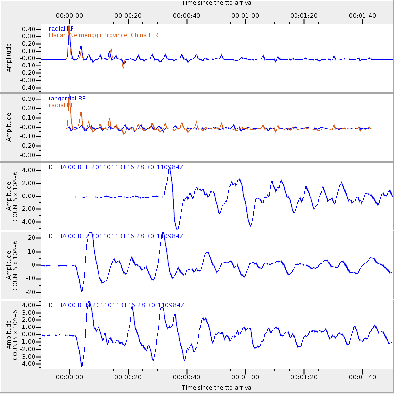
Signal To Noise
| Channel | StoN | STA | LTA |
| IC:HIA:00:BHZ:20110113T16:28:30.110984Z | 111.612366 | 8.394913E-6 | 7.52149E-8 |
| IC:HIA:00:BHN:20110113T16:28:30.110984Z | 26.627998 | 1.8603771E-6 | 6.986546E-8 |
| IC:HIA:00:BHE:20110113T16:28:30.110984Z | 22.100727 | 1.9995855E-6 | 9.047601E-8 |
| Arrivals |
| Ps | 4.0 SECOND |
| PpPs | 15 SECOND |
| PsPs/PpSs | 19 SECOND |


